
Tel Lachish National Park – Visitors Guide

Tel Lachish is associated with the Biblical city of Lachish. And in the Kingdom of Judah, Lachish was second in importance only to Jerusalem.
Map
Tel Lachish is located in southern Israel, about 13 km from Kiryat Gat. It is also only 10 km from Beit Guvrin National Park and about 60 km from Jerusalem.
Tel Lachish is located by the Lachish stream, which starts from the mountains near Hebron and meets the Mediterranean Sea near Ashdod. And in Ashdod, by the river, you can find Lachish River Park.
Directions for drivers: Link to Waze and Link to Google Maps
Directions for public transport: Link to Moovit
Interactive map of the area:
Note: Tel is an archeological term meaning human-made mound. You can find additional information at Tel Megiddo National Park.
Here is basic information with maps:
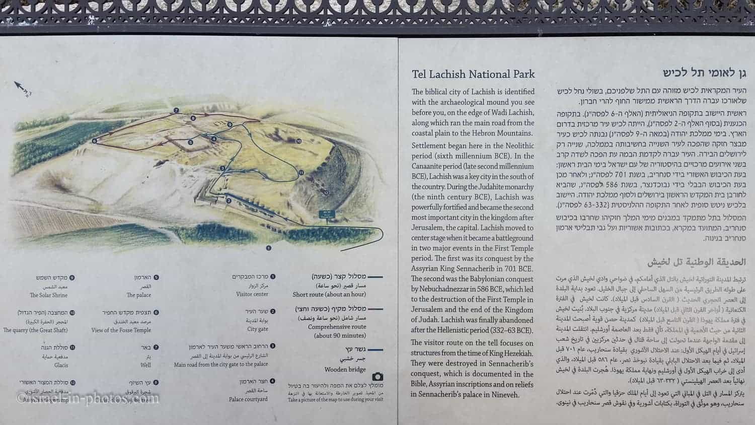

Note: you can click on the map to enlarge it.
Tracks
As you can see from the image above, there are two possible tracks. The short route (green) takes about an hour, and the longer track (green and red) takes one and a half hours and leads you through all the points of interest on the top of the Tel.
Opening Hours
Sunday – Thursday and Saturday: 8:00 – 17:00 (16:00 in winter).
Friday: 8:00 – 16:00 (15:00 in winter).
On holiday eves, usually 8:00 – 13:00.
Note: Since the pandemic, the Israel Nature and Parks Authority has started limiting the number of people in each park. Thus, reservations are recommended through the official site (you can find the link below).
Entrance Fee
Adult 24 NIS, child 10 NIS, and student 20 NIS. Free for National Parks annual subscribers.
If you visit multiple National Parks, consider purchasing a combo ticket. Additional information is available at National Parks and Nature Reserves.


Visitor Center
Inside the visitor center, you can find the ticket office, a small store, restrooms, and a small exhibition. After purchasing tickets, a worker at this national park told us that a movie was about to start. We saw a short movie depicting the history of Tel Lachish and started our tour.


Notes:
- Lachish Letter – A letter in ancient Hebrew mentioning Lachish was discovered at the city gate (sixth century BCE, replica).
- Did you know that Lachish is mentioned 22 times in the Bible?
The Battle Of Lachish
Several years ago, when we visited the Israel Museum in Jerusalem, I saw the impressive relief of the Battle of Lachish (replica).

This relief provides a realistic depiction of the conquest of Lachish in 701 BCE. It graced the walls of an entire hall in the palace of King Sennacherib at Nineveh, underscoring the significance of this victory from the Assyrian perspective.
On the left, the Assyrian soldiers, armed from head to toe, attack the city, aided by a siege ramp and battering ram. Opposite them, the Judahite defenders stand atop the walls, raining arrows, torches, and sling stones down on their attackers. In the center, the Assyrian soldiers impale captives on poles and carry off spoils while families of Judahite refugees head into exile, their possessions laden on carts. The right side of the relief depicts Sennacherib reviewing the procession of captives and booty. The legend reads: “Sennacherib, King of the World, King of Assyria, sat upon a Nemedu-throne and the spoil from Lachish passed in review before him.”.
Original in The British Museum, London
Source: Israel Museum

This battle was the turning point of the Biblical city of Lachish. But there were additional events in the history of this city. Let’s overview them.
History
Tel Lachish, the mound of the ancient city of Lachish, is located in the lowlands of the Judean Hills, some 40 km. Southeast of Jerusalem. The abundance of water sources and the fertile valleys of the area favored the existence of a prosperous city over a considerable period.
The mound of the city was first excavated during the 1930s. Systematic and in-depth excavations of large mound areas were again conducted between 1973 and 1987.
The Canaanite city
A large, fortified Canaanite city was established at the beginning of the 2nd millennium BCE on a hillock dominating the surrounding area. It was fortified by a wall and a glacis, a ramp-like structure of compressed earth with a hard, smooth surface of lime plaster. The fortification was completed by a fosse (moat) at the foot of the glacis.
A large palace of numerous rooms and a courtyard, probably the Canaanite King of Lachish residence, stood on the acropolis – the highest part of the city. It could not be completely exposed, as a later Israelite palace was built above it.
From letters sent by the kings of Lachish to their overlords, the pharaohs of Egypt (the 14th century BCE el-Amarna correspondence), it may be deducted that Lachish was an important urban center and the seat of the Egyptian governor of southern Canaan.
Two temples are known from this period at Lachish. Finds from the Fosse Temple, at the western foot of the mound, include cult vessels, offering bowls, and imported items of pottery, faience, and ivory, all evidence of wealth. The temple on the Acropolis, with Egyptian architectural elements, included an entrance chamber, the main hall (16 x 13 m.), and a raised holy of holies. Two octagonal stone columns supported the wooden ceiling, while the walls were decorated with painted plaster.
Canaanite Lachish was totally destroyed by fire at the end of the 12th century BCE. According to one theory, the destruction was wrought by the Philistines of the nearby Coastal Plain; according to another, more widely accepted theory, it was wrought by the Israelites, whose capture and destruction of the city is recorded in the Bible. (Joshua 10:31,32)
The Israelite city
Rebuilt as a fortress-city of the Kingdom of Judah, Lachish gained importance after the split of the kingdom into Judah and Israel. As the largest city on the western border of the Kingdom of Judah facing the Philistines of the Coastal Plain, Lachish was fortified with a double line of massive mud-brick walls on stone foundations. The main city wall on top of the mound was 6 m. wide, with a sloping glacis supported by a revetment wall along the middle of the slope. In the southwestern wall, the city gate is one of the largest and most strongly fortified gates known of