Beit Guvrin – Maresha National Park – Full Visitors Guide
Beit Guvrin – Maresha National Park has numerous caves (southern area), an amphitheater, and a fortress in the northern region.
Table of Contents
Map
Beit Guvrin National Park is near Kiryat Gat, roughly halfway between Jerusalem and Tel Aviv. Beit Guvrin is about 55 km from Jerusalem and 80 km from Tel Aviv.
Directions for drivers: Link to Waze and Link to Google Maps
Directions for public transport: Link to Moovit
Interactive map of the area:
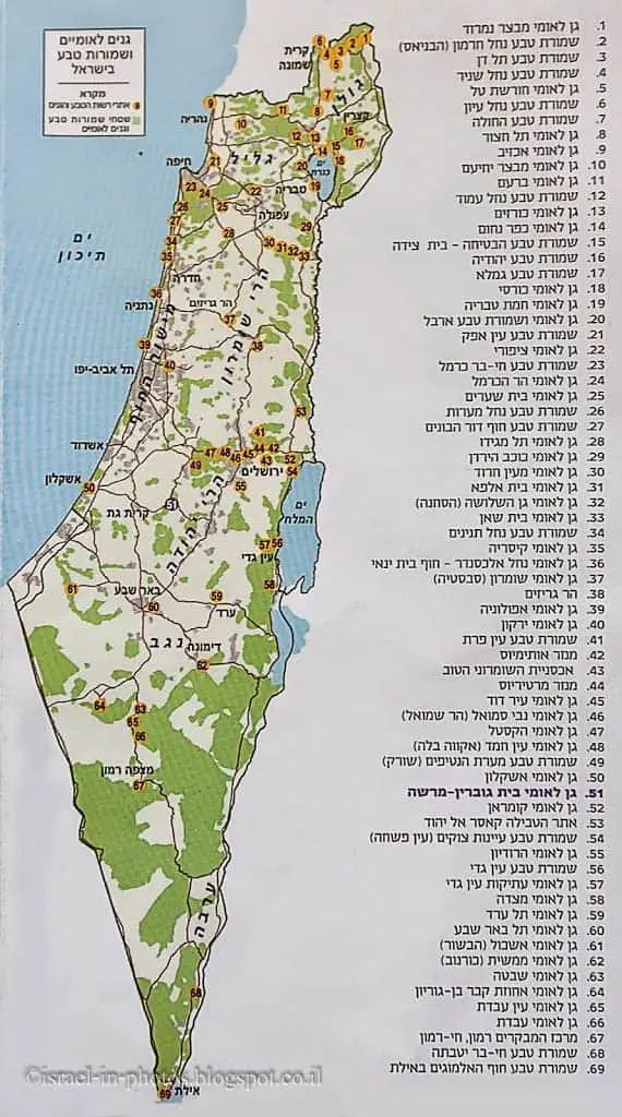
And here is the map from the official brochure.
Note: you can click on the map to enlarge it.
Note: you can click on the map to enlarge it.
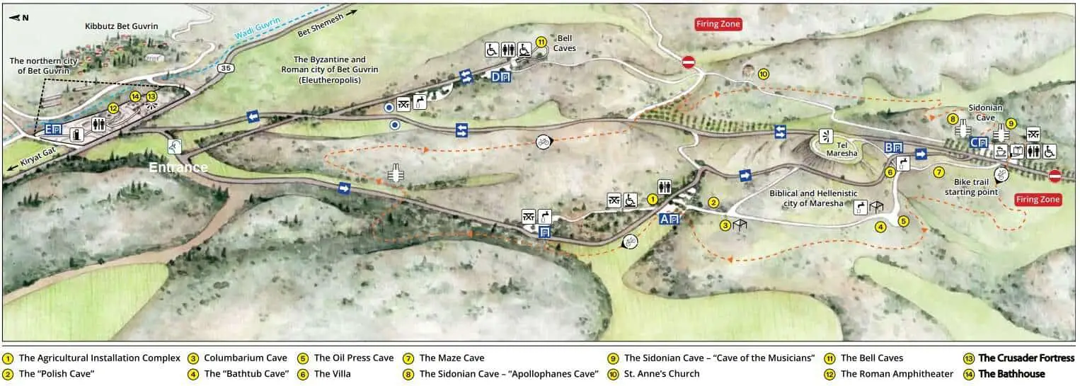
There are two geographical parts to this national park, which is divided by road #35.
- The northern area presents the Beit Guvrin Amphitheater and Crusader Fortress.
- The southern part is the bigger one. You can see all the caves, including the Bell and Sidonian caves.
Both entrance points are shown on the left of the map. The “Entrance” string marks the entrance to points of interest #1-11. And the approach to places #12-14 is behind the gas station on the other side of road #35.
Tracks
Beit Guvrin is quite a big national park, and this post results from many visits. Because on many of the visits, we were with kids, such as easy-going half-day visits. If you want to cover the whole park, it will probably take you half to a full day. But you can also make shorter, several-hour highlight tours. Here are the trails that the Israeli Nature and Parks Authority offers:
- Highlights tour – this is a two-and-a-half-hour route starting at parking lot A. Then, walk to the agricultural complex and installations (#1) and the Columbarium Cave (#3). Next, take the car to park lot B to visit the Maze Cave (Cave System #7). Afterward, drive to parking lot C to see the Sidonian Cave (#8). Drive to parking lot D to visit the Bell Caves (#11). And lastly, go to parking lot E and visit the Roman Amphitheater (#12).
- See it all trail – this is a three to four-hour foot trail. It also starts at parking lot A. From there, walk about 1.5 km long. In that 1.5 km, you will visit the Columbarium Cave (#3) and the Sidonian Cave (#8). Either walk back to your vehicle or continue another 2 km on foot to the Church of St. Anne (#10) and the Bell Caves (#11). And about another one km to the Roman Amphitheater (#12).
- Using the Handicapped and Stroller Accessible trail, you can visit the agricultural installations complex (#1), the visitor service center (near the Sidonian Caves), the Bell Caves (#11), and the Roman Amphitheater (#12).
Directions
To reach the park, use the links above the interactive map.
Notice that this national park is close to the Green Line. If you miss the exit to Beit Guvrin and continue along road #35, you will reach Hebron.
My favorite way to get there, and also the fastest from the Israeli center, is to drive on toll highway #6 until Kiryat Gat and then take road #35. Another option, which is longer but does not include toll roads, is driving through Bet Shemesh.
You can reach this site by bus. You can either take bus #66 or a taxi from Kiryat Gat. Remember that this is a big park. Even if you get to the park entrance by public transport, you must get from point to point inside the park. Since the park is spread over a vast territory, there are several parking lots. Most people drive from one point to another within park limits. Thus, visiting by car is the preferred option.
Opening Hours
Sunday – Thursday and Saturday: 8:00 – 17:00 (16:00 in winter).
Friday: 8:00 – 16:00 (15:00 in winter).
On holiday eves, usually 8:00 – 13:00.
Note: Since the pandemic, the Israel Nature and Parks Authority has started limiting the number of people in each park. Thus, reservations are recommended through the official site (you can find the link below).
The last entrance to the park is allowed one hour before the closure.
Entrance Fee
Adult – 28 NIS, child – 14 NIS, and student – 24 NIS. Free for National Parks annual subscribers.
If you visit several National Parks, consider purchasing a combo ticket. For additional information, see National Parks and Nature Reserves.
Note: opening hours and ticket prices were updated in June 2024. In any case, recheck the official site before visiting.
Benefits of Beit Guvrin
Beit Guvrin National Park is a UNESCO World Heritage site that offers a visit to human-made caves and an ancient city. It is also one of my favorite national parks in Israel, so I included it in National Parks And Nature Reserves‘ top ten list.
First, I find it fascinating that people build such complex underground systems. You can even call them cities. They constructed everything using only basic tools. Moreover, besides its uniqueness, here are the reasons why I love this park:
- During your visit, you will spend a lot of time underground. That means there is no sun, and it is colder inside the caves. In general, caves are better suited for a summer visit.
- Another reason is the kids. Children love this place. Giving them a flashlight and allowing them to explore makes them feel at the top of the world.
- Beit Guvrin is quite large. Thus, if you are visiting with small kids, you will most likely not see everything in one visit. That allows you to return on another day and choose what to see.
Southern Part of Beit Guvrin
In this section, we will explore the cave in the southern area.
After entering the southern part of Beit Guvrin, we usually start at parking lot A (and not only because there are restrooms there). You can either drive between parking lots (and then visit each nearby cave on foot) or leave your car and hike. Though the distances are not too considerable since we were with kids and some visits were on hot days, we usually chose the first option.
The “Polish Cave”
We walked to The “Polish Cave” (number #2) on the map from parking lot A.
Why is it called the “Polish Cave”?
This is a cistern hewn in the Hellenistic period. In the middle is a block of stone, part of a pillar that supports the ceiling. At some point, niches to raise doves were carved into the cistern walls. During World War II, Polish soldiers from the army of General Wladyslaw Anders – loyal to the Polish government in exile in London – visited this cave. They carved the figure 1943 (the year of their visit) into the pillar, along with an inscription: “Warsaw, Poland” and an eagle, the symbol of the Polish army.
Note: unless stated otherwise, all quotes were taken from the official site.
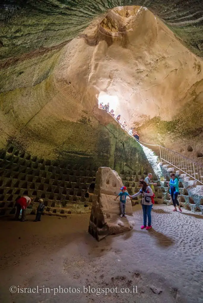
This cave has a columbarium. The birds were used for messaging (an ancient post office) and food.
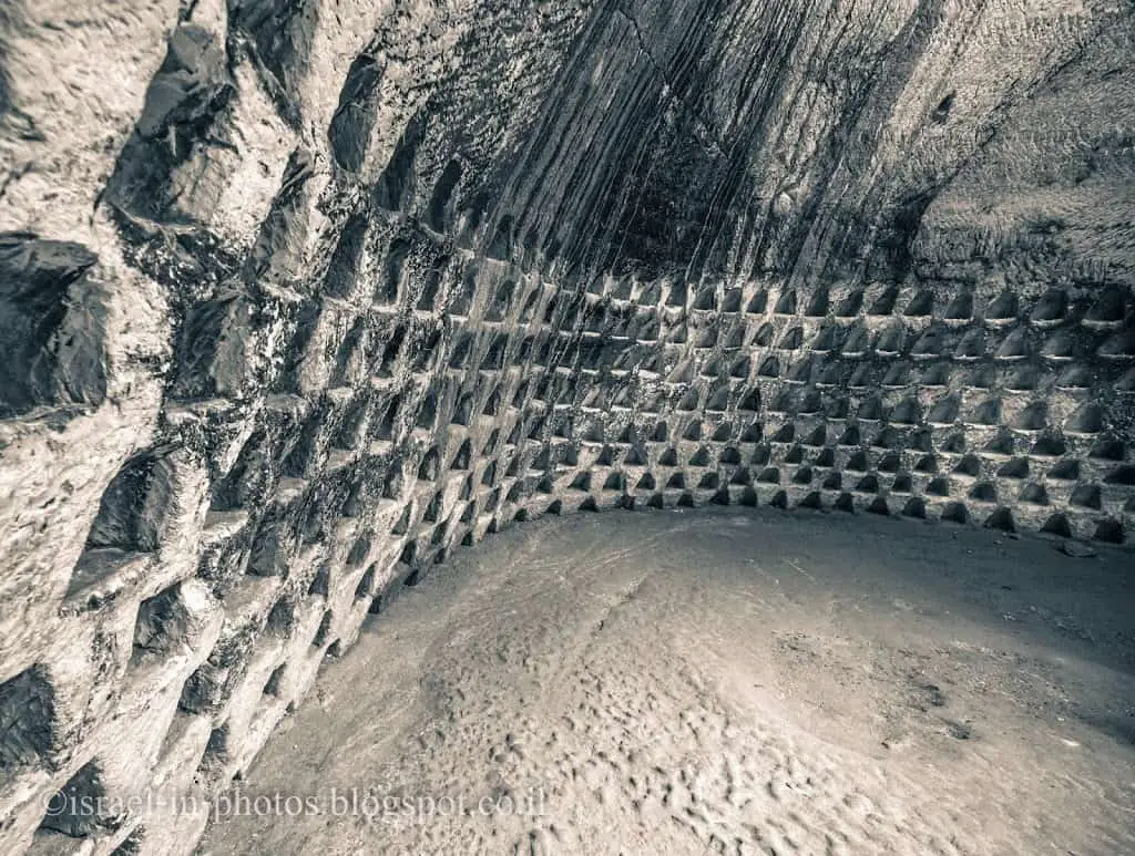
The Columbarium Cave
From #2, we continued to #3, The Columbarium Cave. This underground structure with a columbarium is much bigger than the previous one.
A columbarium is an installation to raise doves. The word comes from the Latin Colomba, which means dovecote. The walls of this cave feature a high-quality design and are carefully carved with over 2,000 niches. The raising of doves was widespread in the Judean lowlands during the Hellenistic period. Doves were used intensively – their meat and eggs as food and their droppings as fertilizer. Doves were also sacrificed in rituals. After raising doves as a prosperous industry ceased in the 3rd century BCE, other purposes were found for this cave, like many others at Maresha. In Maresha alone, some 85 Columbarium caves have been discovered, with tens of thousands of niches.
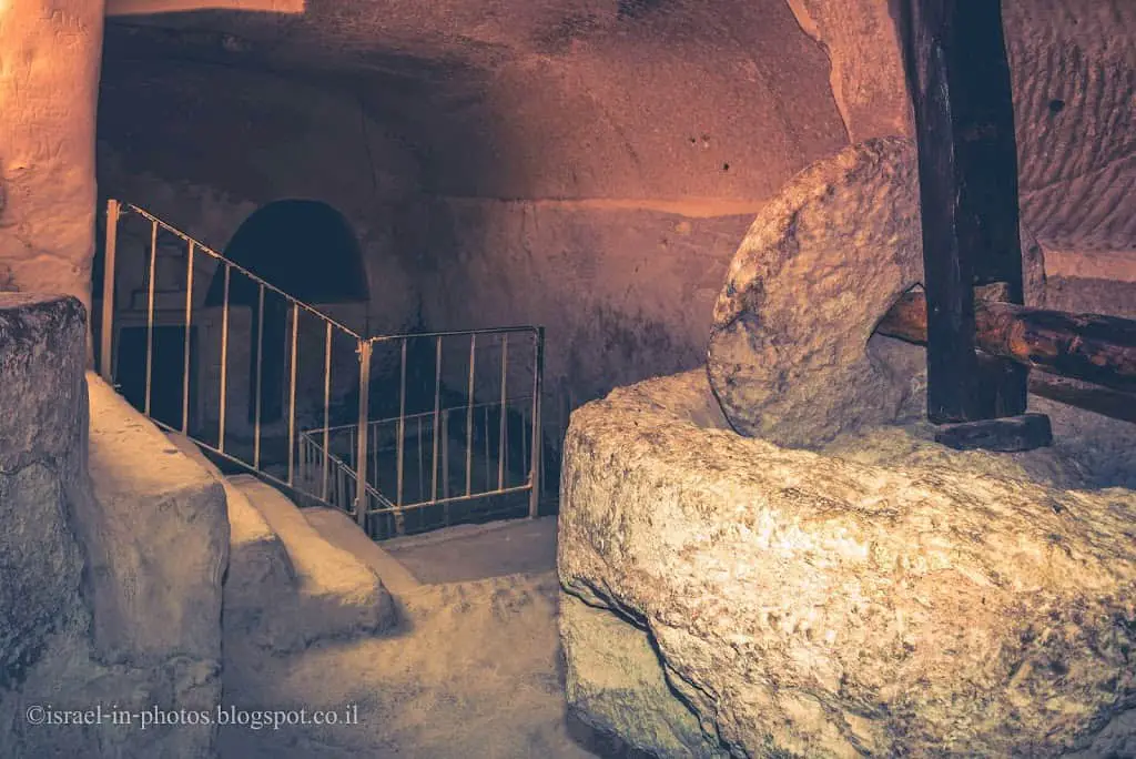
The Oil Press Cave
From the Columbarium Cave, we continued to The Oil Press Cave (#5). We hiked there, but you can also take the car to Park Lot B and walk.
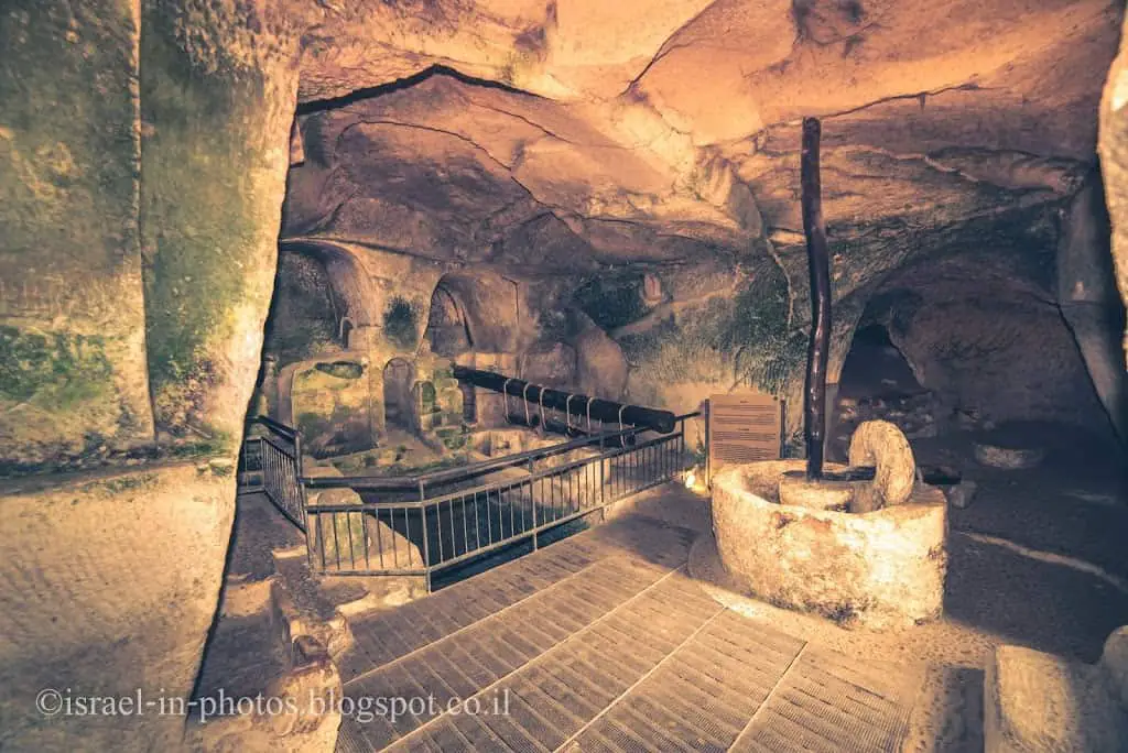

This is one of 22 underground oil presses discovered in Hellenistic Maresha. Most of them have one crushing installation; two or three feature press beams.
Olive growing was a significant source of income in Hellenistic Maresha (3rd-2nd centuries BCE). This olive press was built in a previously existing cistern.
They did olive pressing in the following manner:
- Crushing (the right part of the photo below): The olives were placed in a large, round, flat stone basin, and a lens-shaped crushing rock moved vertically around them.
- Squeezing (the photo above): After crushing, the olives were put into woven baskets and placed on each other. The baskets were placed under a broad beam (inside the niches in the back of the photo). Three weights (in the left part of the picture) were tied to the beam to increase the pressure.
- Collection – the oil and water were collected in hewn basins beneath the baskets.
Maresha
Maresha is an ancient city founded during the Israelite period. The town was located on a high hill, hence its name (Rosh means head in Hebrew).
Tel Maresha rises to 357 m above sea level, with the upper city, or acropolis, about 30 m above the lower city. The appearance of the steep, terraced-looking slopes of the upper city is due to the remains of walls surrounding the city for 800 years, from the Israelite period to the end of the Hellenistic period (9th–1st centuries BCE). Square corner towers were integrated into the city wall; one can be seen in the northwestern corner of the tell. The top of the tell affords an impressive view of the national park and its surroundings.
Beit Guvrin (translating from Hebrew, meaning “the house of strong men”) is an ancient city that became important after Maresha was destroyed. It continued from the late Hellenistic until the end of the Byzantine period.
Unfortunately, there is almost nothing to see at Tel Maresha currently. Thus, though it is mentioned, no number is next to it.
You can hike to it from parking lot B.
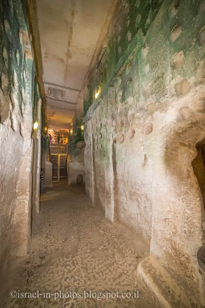
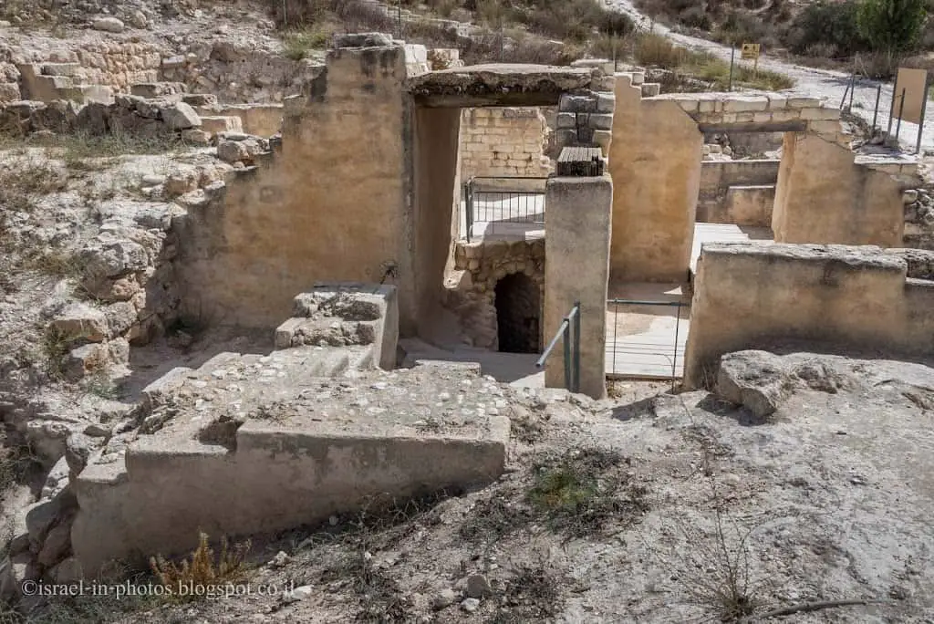
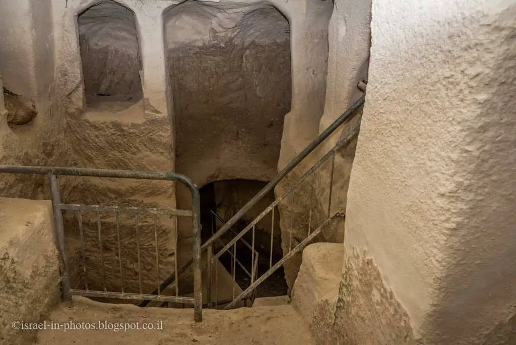
Dwelling (the Villa)
From parking lot B, we walked to Dwelling (#6), a Citstern complex under Maresha’s houses.

Excavations at the beginning of the ’90s revealed an urban section, including residential and shopping areas, dating to the 3rd- 2nd centuries BCE. Each residential house had a central yard surrounded by rooms and a second floor. The residents quarried cisterns under the homes of the lower city. These cisterns were used for different purposes: water halls, baths, columbariums, oil presses, storage, etc.
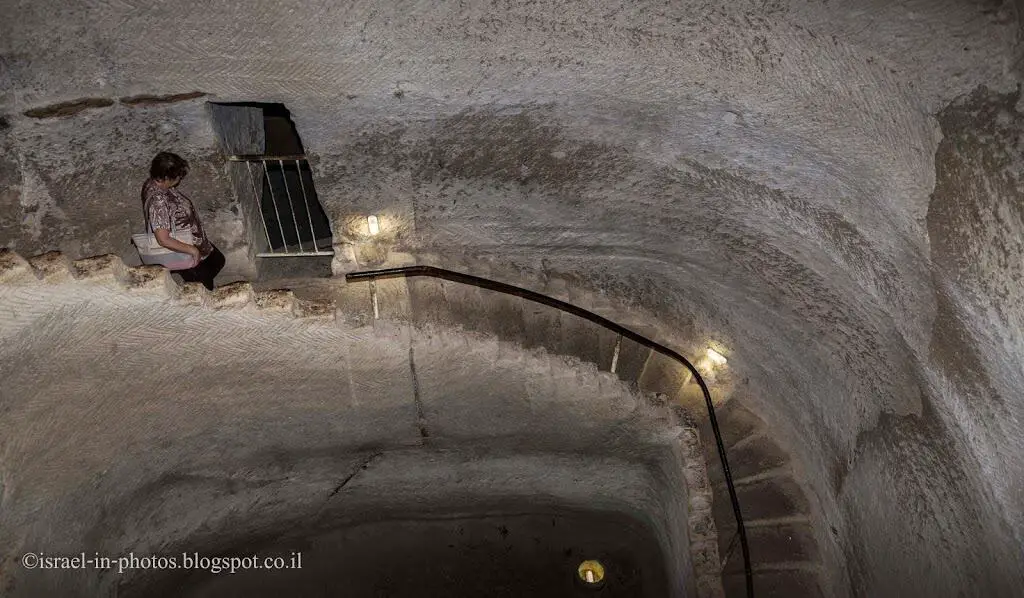
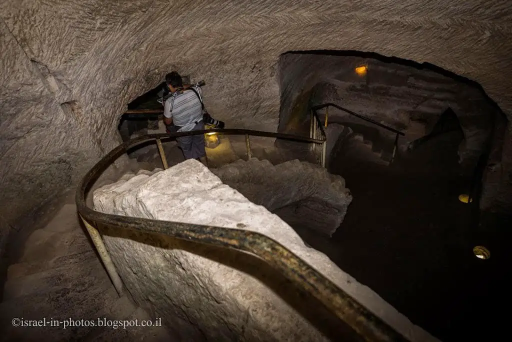
Each cistern or cistern complex had its staircase descending from the house above. Without ascending to ground level, the connection between different cisterns results from functional changes from later periods.
And this is how the urban section looks at ground level:
The Sidonian Caves
We returned to parking B and drove a few minutes until parking lot C. Parking C is close to The Sidonian Caves (#8 and #9).

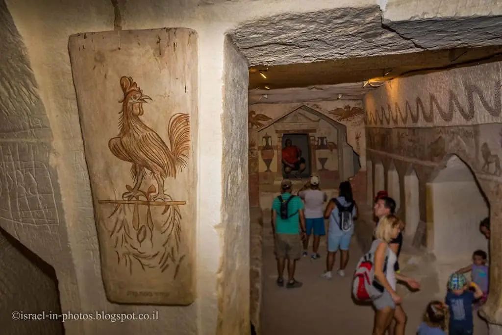
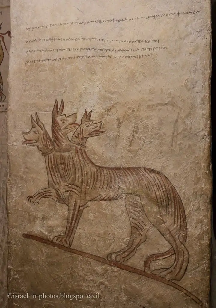
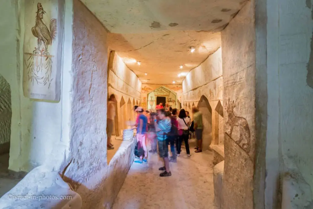
These are the Sidonian burial caves, the only ones with paintings inside. They were burial caves for the Greek, Sidonian, and Edomite inhabitants of Beit Guvrin.
Sidonian burial cave #8 is the most impressive one. Of course, the paintings are not original. This one underwent reconstruction in 1993.
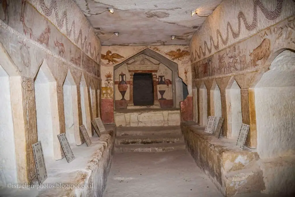
During the Hellenistic period, the people of Maresha commonly buried their dead in caves with niches. Two of these caves are seen here. Many of the niches are decorated with gables (a triangular architectural element common on temple facades). In the Apollophanes Cave (8), the northern of the two, an inscription was found mentioning Apollophanes, son of Sesmaios, the leader of the Sidonian community in Maresha. The inscription and the cave’s paintings shed light on the art, mythology, and ethnic affiliations of those interred in the cave (Idumeans, Sidonians, and Greeks). They also reveal their family relationships and burial customs. The Apollophanes inscription identifies Tel Maresha with biblical Maresha. In the southern cave (9), the “Cave of the Musicians,” paintings have been reconstructed that depict musicians of the period. All the paintings in the caves are reconstructions.

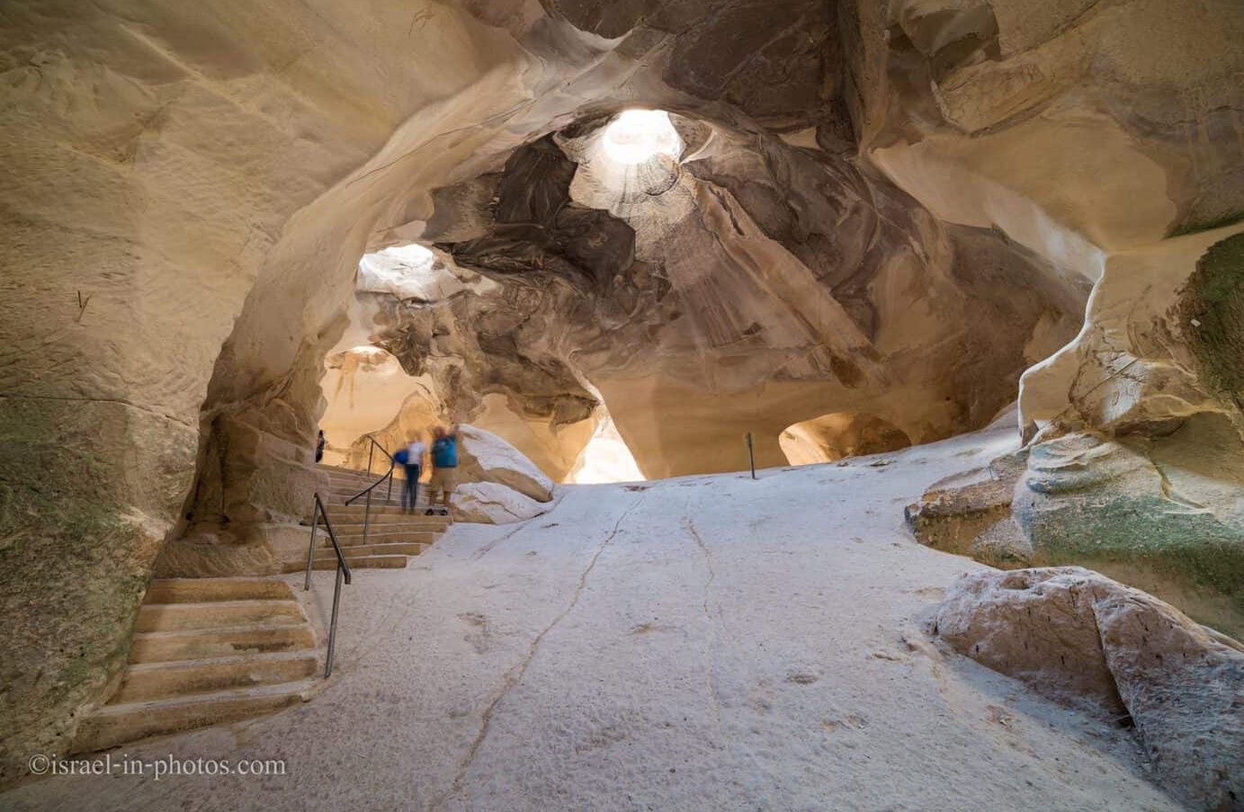
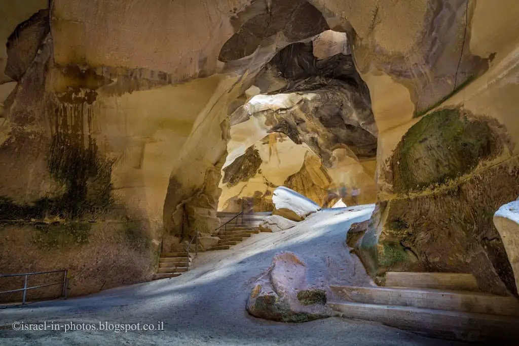
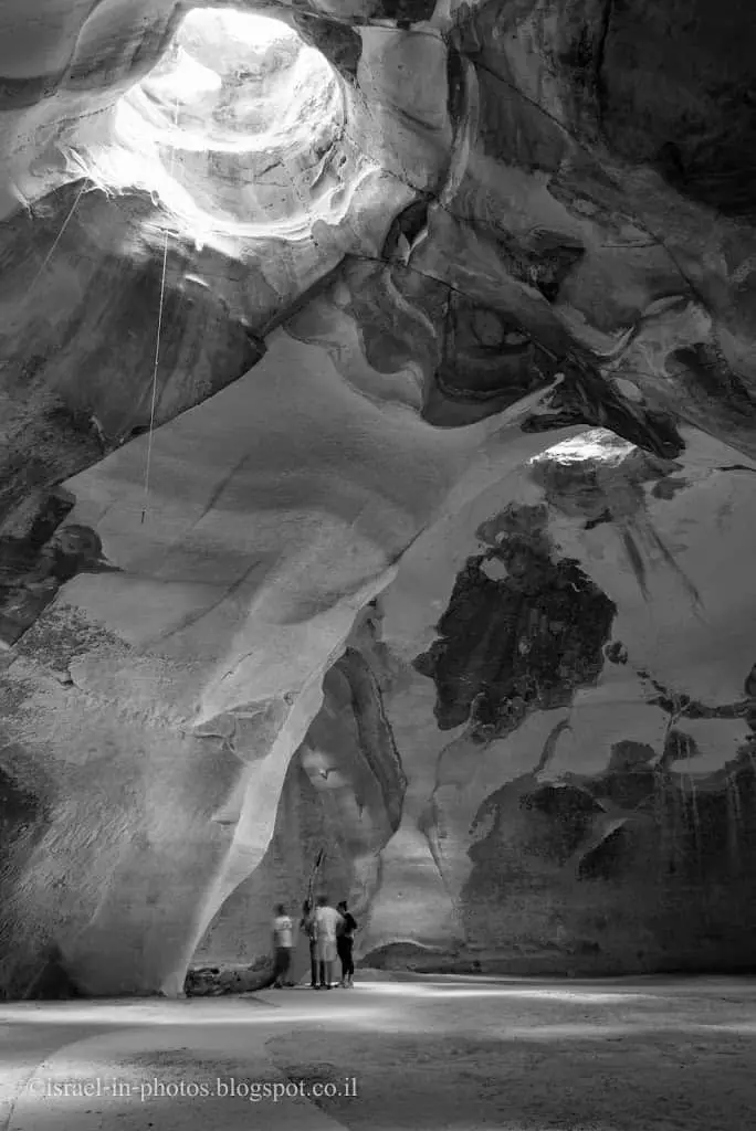
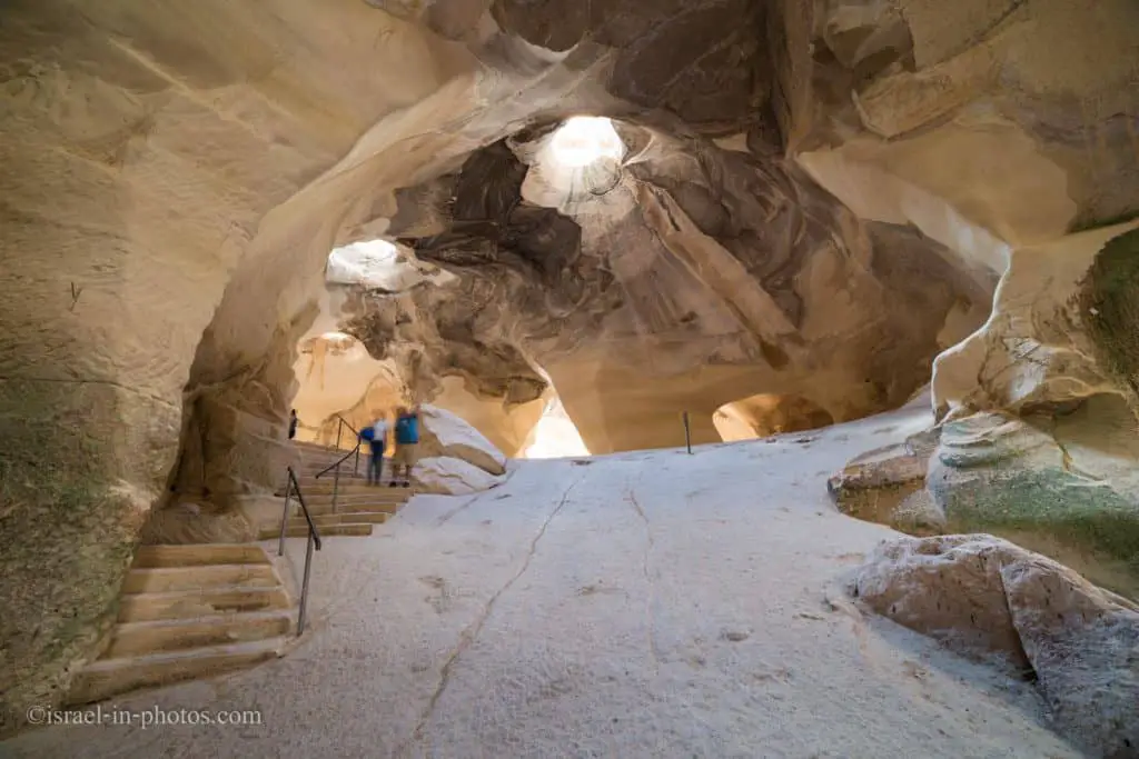
The Bell Caves
Near parking lot D, you can find the Bell Caves (#11).
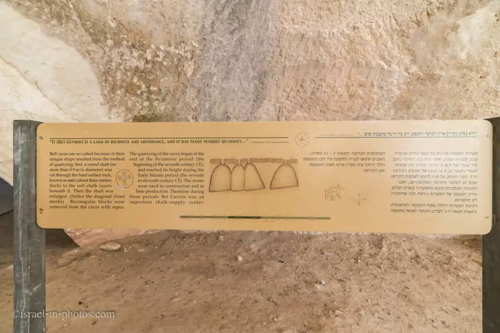
There are many bell-shaped caves (around 800) in this area. And Beit Guvrin National Park is in the middle of this area. Moreover, many caves are linked via an underground network of passageways connecting 40-50 caves.
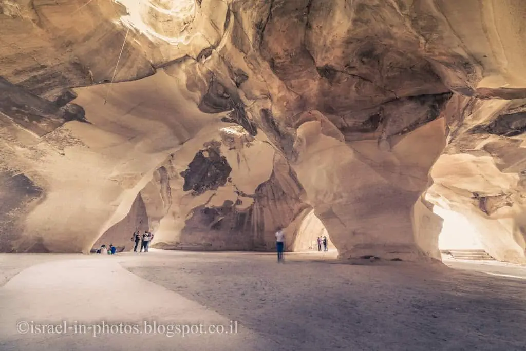
Here is an extensive complex of Bell Caves. How was such a form created? It is a quarry. It was used to carve stones, which were used for construction.
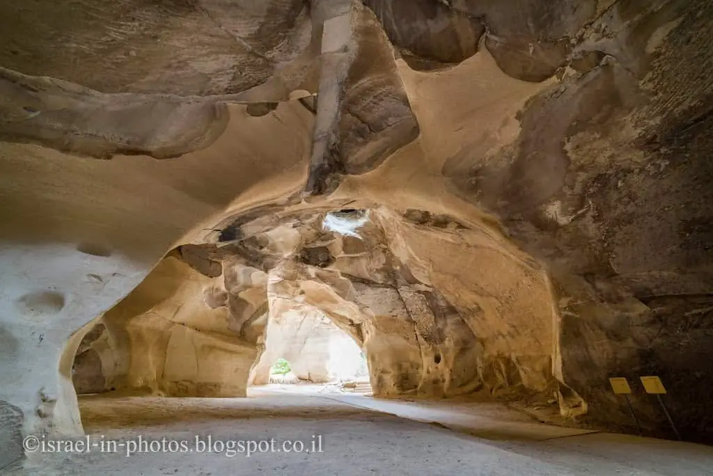
You can see a wheelchair-accessible route from the entrance.
While photographing, I did not notice the rope coming from the top of the cave (in the photo below). Only at home at 100% zoom did I see a microphone at the rope’s end. The acoustics inside the Bell Caves are excellent, and concerts are held occasionally.
These were the main points of interest in the southern part. Let’s cross the road (#35) and visit the northern city.
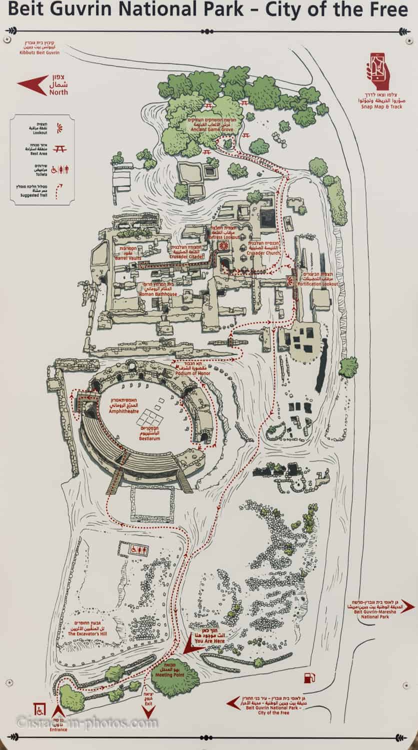
Northern City of Beit Guvrin
On the Northern side of the road, you can find attractions #12 – #14.
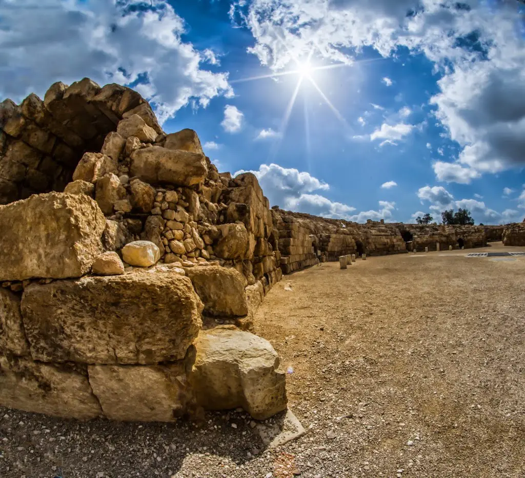
Beit Guvrin Amphitheater
On this side, only one parking area (parking lot E) exists. The first thing you see is Beit Guvrin Amphitheater (#12).
Note: this is the only Amphitheater in Israel. Do you know what the difference between the Roman Theater and Amphitheater is? For a full explanation, see Is Caesarea Amphitheater really an amphitheater?

A Roman amphitheater was a public structure for sports competitions and spectacles like fights between gladiators or against wild animals. A theater, on the other hand, was used mainly for plays. Other than the differing purpose, these two structures differ in form. The theater is semi-circular, while the amphitheater is round or elliptical, with the seating area completely encircling a round arena. Beit Guvrin has the only Roman amphitheater in Israel that is open to the public. It had 3,500 seats built around the arena, with spaces beneath the area to hold the wild animals.
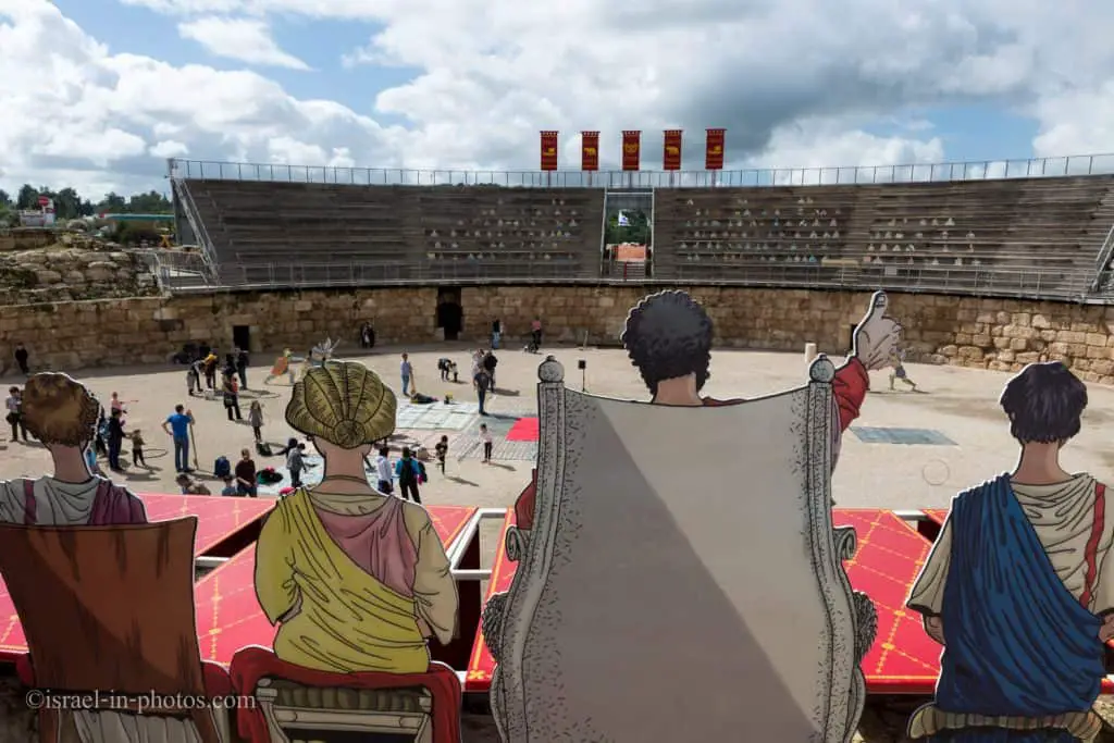
The central area of the amphitheater was called the Arena. The word arena comes from the Latin word for “sand” since the ground was covered with sand to absorb the combatants` blood.
From the fifth century, it served as a trading market, and during the Middle Ages, part of it was used as a stable and a manufacturing area.
Source: sign
Note: I took some photos with an old fisheye lens, thus the black circle on the picture’s edges.

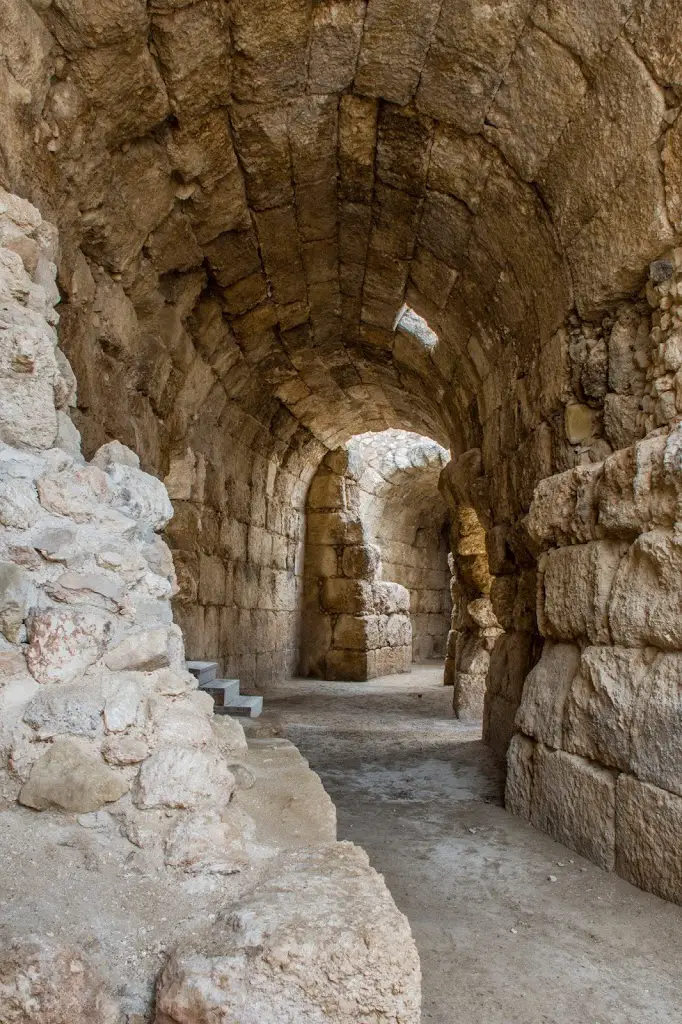
The Amphitheater, built in the 2nd century, could seat about 3,500 spectators. It was a walled arena of packed earth with underground galleries. The stadium was surrounded by a series of connected barrel vaults, which formed a long, circular corridor and supported the stone seats above it.
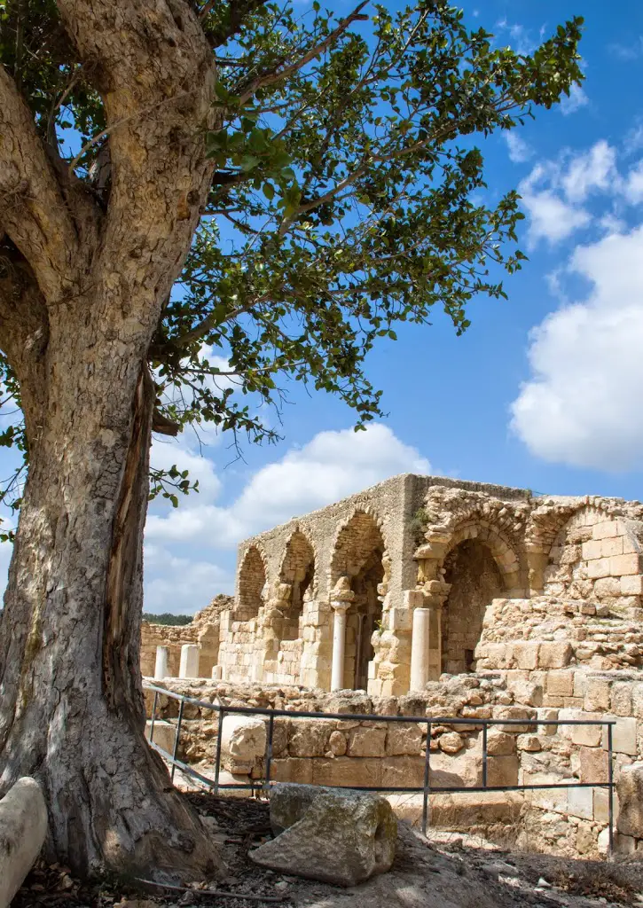
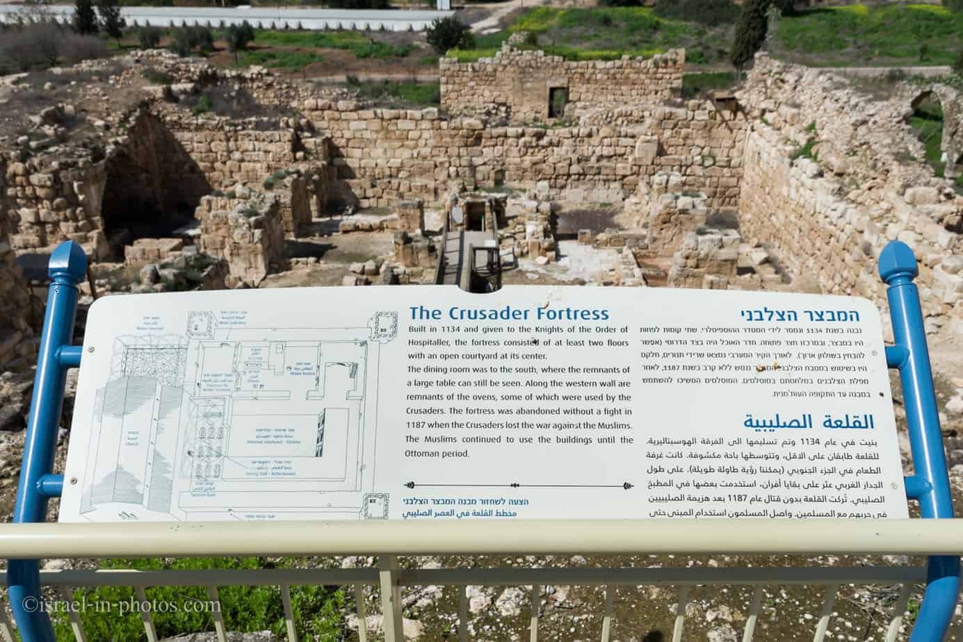
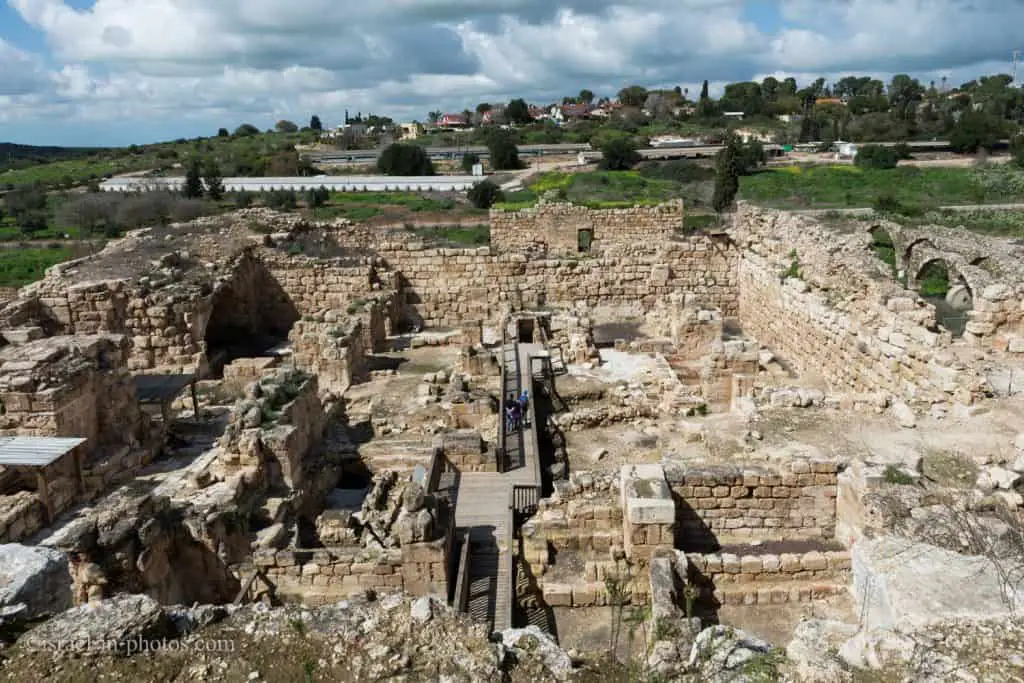
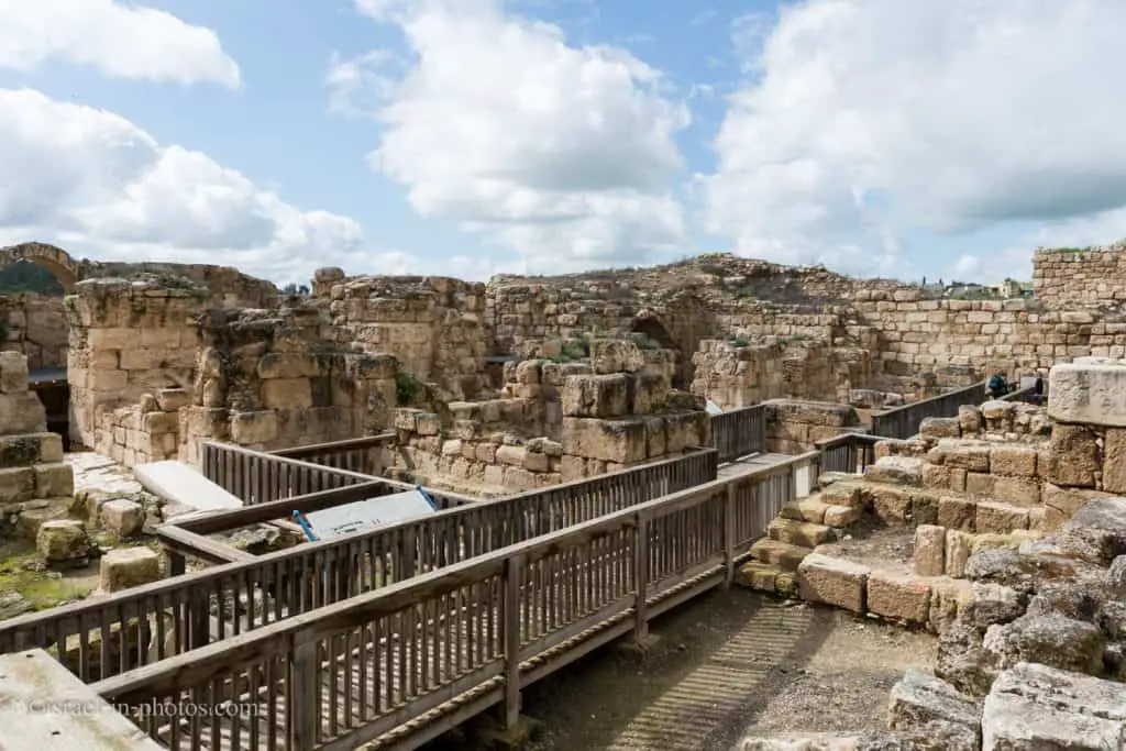
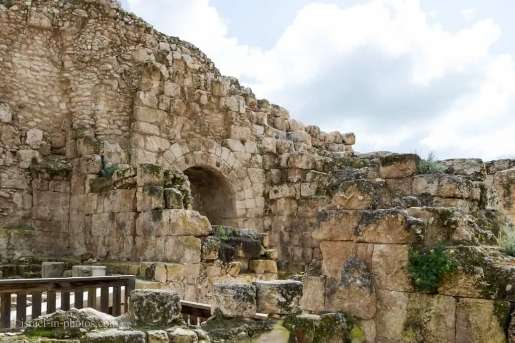
The Crusader Fortress
Behind Beit Guvrin Amphitheater, you can find The Crusader Fortress (#13).

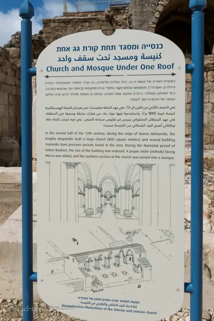
The Crusader fortress is located east of and adjacent to the amphitheater. A basilical church built-in 1136 by King Foulk d’Anjou of Jerusalem was found in the fortress. The church, built in the Romanesque style, served the people living in and around the fortress. The church was adorned with Roman and Byzantine stone bases, columns, and capitals taken from the remains of ancient Beit Guvrin.
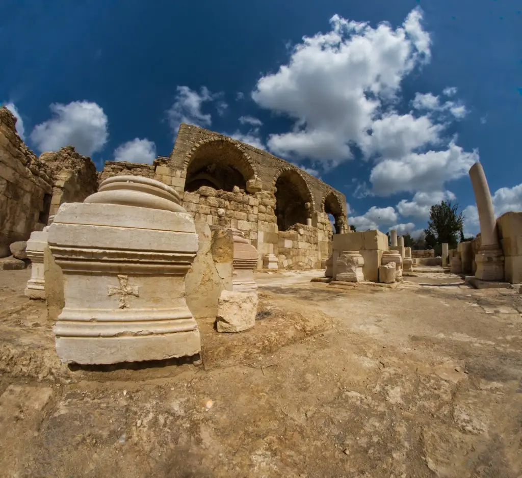
One interesting fact is that this building served both as a church and a mosque.
On top of the Crusader Fortress, there is a viewpoint. Once you climb to the top, you can see the surrounding area, including the bathhouse.

Bathhouse
The Roman bathhouse is the only imperial bathhouse discovered so far in Israel and is similar to the ones built in Rome. The magnificent structure was built in the 3rd century and covered 10,000 square meters. It was used by the public from the 3rd to the 7th century and consisted of pools, baths, hot rooms, warm rooms, a cold bathroom, steam rooms, massage rooms, toilets, dressing rooms, and a courtyard. In the 12th century, the Crusaders built a fortress on the ruins of the bathhouse.
Source: sign
Note: the bathhouse is marked as #14 on the map.
The Romans were aware that the area is earthquake-prone and that the local calcrete stone is not particularly strong. To compensate for this, they installed double arches and built the bathhouse to a very high standard.
Source: sign
Dig For A Day
Dig For A Day is an archeological adventure. And during 2024, we participated in this activity.
Here is the basic info so that you will know what to expect:
Entrance Fee: 95 NIS per adult and 72 NIS per child (above five years old). Children who are less than five years old enter for free. Also, this entrance fee does not include entrance to this national park (so you must buy both entrance and tour tickets). But there are coupons online. I purchased tour tickets for 59 and 49 NIS, respectively.
The Activity: When purchasing the tickets online, you select the day and time. You will meet an archeologist at parking lot B at the chosen time, and the activity will begin. Our guide gave us an archeological overview, and then we went to nearby caves (these caves are closed to the public, and you can only enter with a guide). We performed archeological excavation inside the cave, carried all the buckets outside, and performed sifting to find small items. Our group found many bones, ceramics, and coal. The last part of the tour included walking and crawling inside an unexcavated cave. This crawling took about twenty minutes, and participation was optional (the insurance does not cover children under five).
Duration of the activity: This visit usually takes about 2.5 hours. In our case, it took three hours. When the tour ends, you return to parking lot B and can continue exploring this national park.
Group size: According to our guide, the group size is about 30 people, but in our case, it was a little more. Most participants were families with kids of various ages.
You can find additional information here.
Here is a nice video by ISRAEL21c that tells about the Dig for a Day Project:
International Bird Migration Day
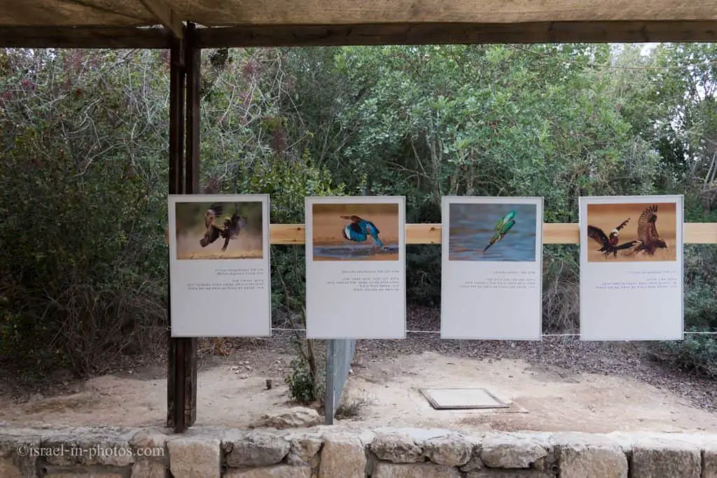
In 2017, we visited International Bird Migration Day, which took place at Beit Guvrin. This event took place at the Bell Caves complex. Thus, as we entered this national park, we turned left and continued to parking lot D.
At the parking, we received the following brochure:

You can see that International Bird Migration Day began at 11:00. We arrived around 10:30. Since we had some time until the activities started, we continued to the bell cave.
We saw a small photo exhibition on our way to the Bell Cave (#3 on this map). Several dozen prints were probably in the shaded area next to the parking.
Here we are at the entrance to the bell caves. The explanation sign tells about the quarrying method that created the caves’ unique shape, hence their name.
Inside the caves, a musician played different pieces on his flute, bagpipe, and other instruments. This station (#10) was called Music Inspired by Birds.
After about half an hour, we left the bell caves and took the long route back to the parking lot.
Activities At International Bird Migration Day
After several minutes, we reached a small tent (#7), where the children were engaged in activities.
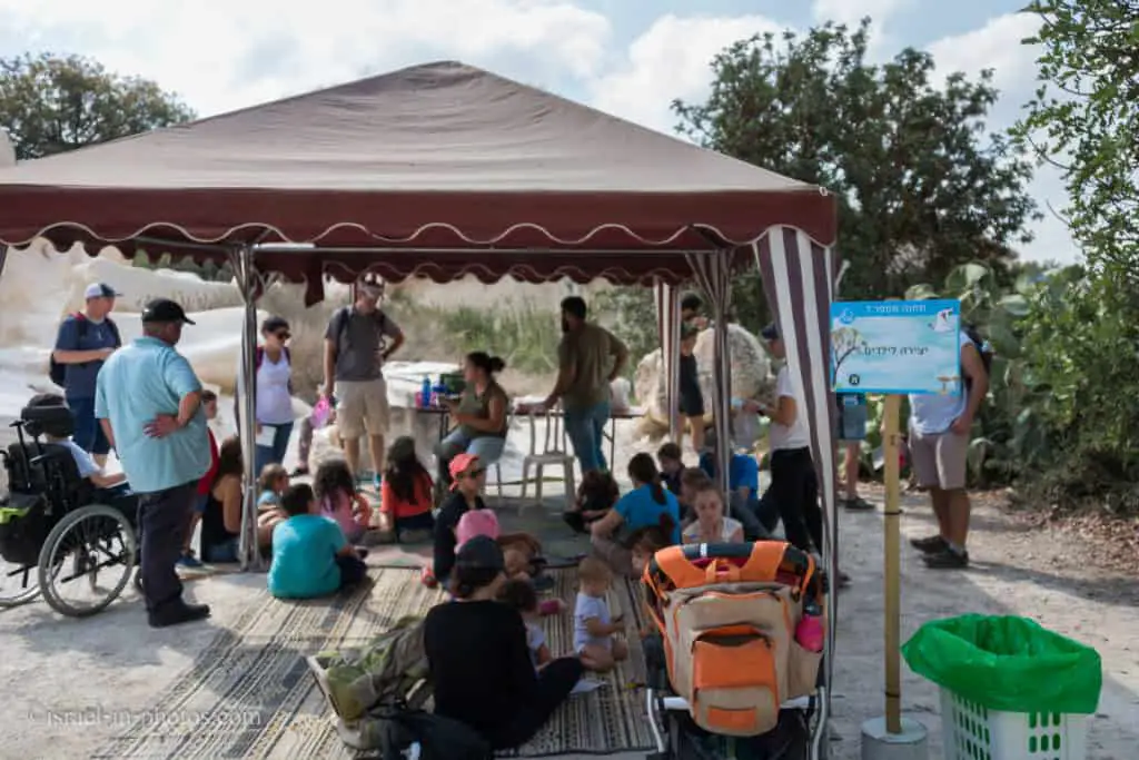
My daughter created and decorated a little flute out of a stem.
Further ahead, we saw many jackdaws. They are nesting in this area, and if you look at the bottom right corner of the next photo, then beyond explanation, you will see a small metal statue of a jackdaw.

Then, we participated in another activity: we created origami birds. However, the instructions were complicated, and only a handful of adults (not to mention the kids) could follow them.

Another nearby attraction was using binoculars to see the names of different birds. There were stands with photos at different places, and each title highlighted one letter. The purpose was to collect all letters and receive a phrase. The positions were too far away, and the binoculars were not very good, so we had a problem seeing the letters.
Moreover, some stands were partially blocked by stones. The idea was nice, but the implementation was lacking. Nonetheless, when we returned the binoculars, my daughter received an International Bird Migration Day sign.
Since it was almost 13:00, we returned to the bus parking to highlight the International Bird Migration Day celebrations.
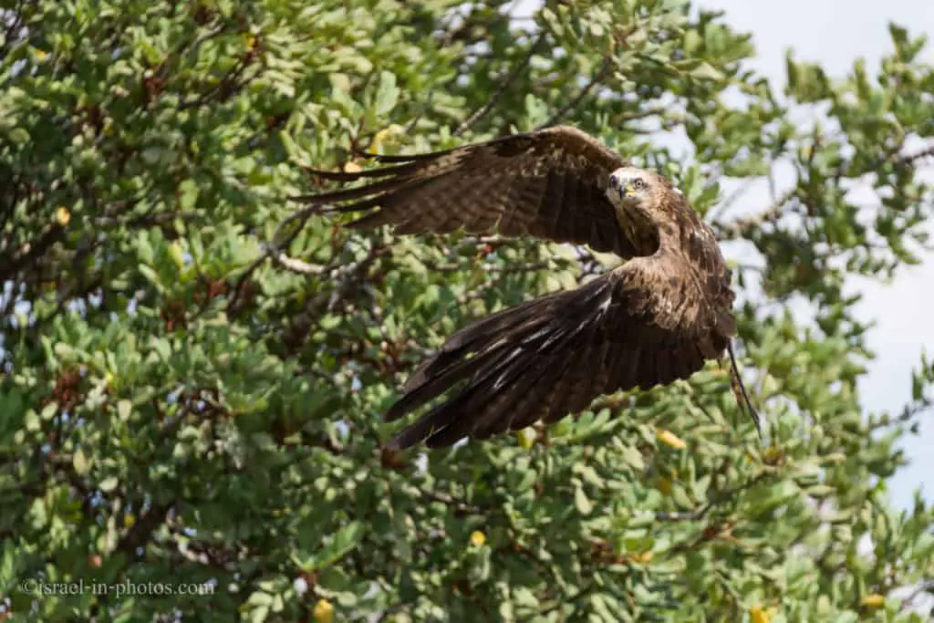
Returning Birds to Nature
We all gathered at the bus parking in a half-circle shape. Then, an instructor told us about the wild animal hospital. The wild animals’ hospital handles 5,000 animals per year, and if you see an injured wild animal, call the Israeli National Parks Authority at the following number: *3639.
At 13:00, they were returning a black kite to nature.

The moment they released the black kite, everything happened very fast. My camera with 4.5 frames per second is not the most suitable (Sony A9 with 20 frames per second increases capture chance). But, luckily I was able to capture this:
We left the International Bird Migration Day event and drove to parking lot C. There is a picnic area, and we had lunch (at the picnic tables near this parking lot) and visited the two Sidonian burial caves.
Sidonian Burial Cave #9 concluded our visit to Beit Guvrin National Park, and we headed home.
I saw several additional activities at International Bird Migration Day but did not participate. One was a movie about birds, and the other was guided tours through bell caves.
Overall, the International Bird Migration Day activities were lovely, and if you have no other plans, check them out.
Historical Background
The History of Maresha
Maresha was fortified by King Rehoboam of Judah following the campaign to the region of the Egyptian Pharaoh Shishak: “And Rehoboam…built cities for defense in Judah…Gath, and Mareshah, and Ziph” (2 Chron. 11:5–8). Shortly after that, in the early 9th century BCE, Shishak’s son sent an army to Judah under his general Zerah, the Ethiopian. However, King Asa of Judah defeated him near Maresha. During the Persian period, after the destruction of the First Temple, Idumeans who came from the Negev settled in southern Judah and the region became known as Idumea.
In the 4th century BCE, Sidonians and Greeks joined them, bringing Hellenistic culture to the region. Hellenistic Maresha was a cosmopolitan center and an industrial magnet and home to a few Egyptians and Jews. Some Jews were descendants of the local population from the time before the destruction of the First Temple, and others came there from coastal cities. The Hellenistic period saw the construction of Lower Maresha; many caves were also hewn during this time.
Historical sources and excavations reveal that in 113/12 BCE, the Hasmonean king John Hyrcanus conquered Idumea and forcibly converted its inhabitants. Hyrcanus also laid waste to the city. Maresha was eventually reinhabited, but its glory days were past, and it remained a small settlement. It was destroyed in 40 BCE in a military campaign by the Parthians, who controlled Western Asia beyond the Euphrates River and who were Rome’s enemies.
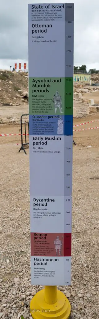
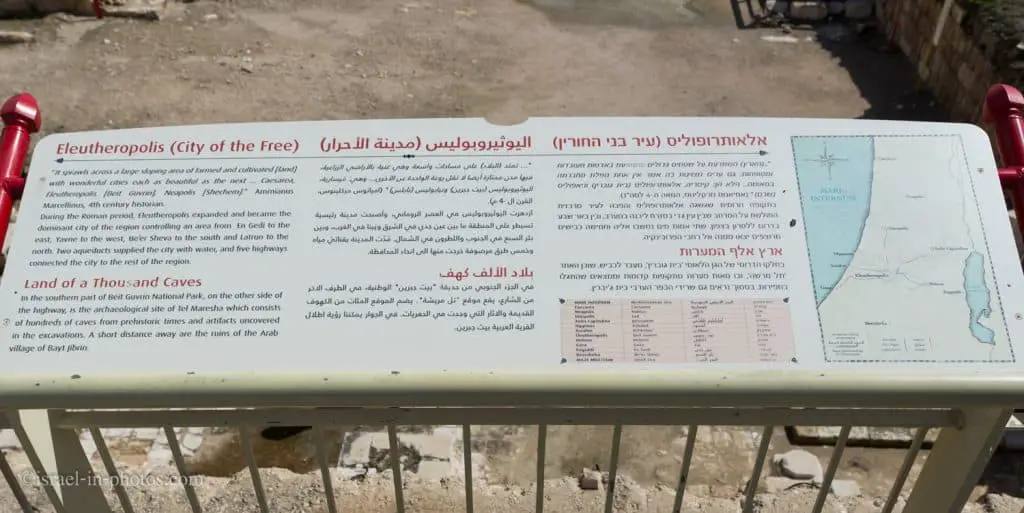
The History of Beit Guvrin
Following the destruction of Maresha, Bet Guvrin became the region’s most important city. Bet Guvrin first appears in the Jewish historian Josephus Flavius’s writings, who reported that the Romans, led by Vespasian, conquered Bet Guvrin in 68 CE. In 200 CE, Emperor Septimus Severus granted Bet Guvrin the city’s status and changed its name to Eleutheropolis (city of the free). The city controlled the coastal plain and the Dead Sea and between Bet Shemesh and the Beersheba Valley. Bet Guvrin became an important junction; five roads, along which milestones have been found, led to the city.
Besides dwellings, the city boasted an amphitheater and other public structures. There are no springs at Bet Guvrin, but during the Roman period, two aqueducts channeled flowing water to the city from springs in the Judean Mountains. Slowly but surely, the city’s Jewish population was renewed. In the 3rd and 4th centuries CE, the town was mentioned in the Talmud and the Midrash. Renowned sages lived there, including Rabbi Yonatan and Rabbi Yehuda Ben-Ya’akov. Further evidence of the growing Jewish population in the region comes from the remains of a large Jewish cemetery and a synagogue inscription.
During the Byzantine period, Bet Guvrin became an important Christian center, and churches were built there. The Early Arab period saw most of the Bell Caves hewn, and during the Crusader period, a small fortified city existed here. The Church of St. Anne was restored at that time, during which small farming villages surrounded the city. The Arab village of Bet Jibrin stood here until Israel’s War of Independence in 1948. In June of that year, the Egyptian army took over the British police station built here at the beginning of World War II. The Israel Defense Forces took the area on October 27, 1948. And Kibbutz Bet Guvrin was founded in May 1949.
Summary
I love Beit Guvrin. I find it fascinating that people built literary underground cities in ancient times. Moreover, since you spend a lot of time in caves, you can visit in summer. And to top all that, it is also enjoyable for kids, making it easier for parents. Furthermore, besides the caves, you can visit the Beit Guvrin Amphitheater, Crusader fortress, and bathhouse.
Beit Guvrin-Maresha is included in the National Parks And Nature Reserves‘ top ten list (for all the reasons mentioned).
Have you ever been to Beit Guvrin? How was it? Tell us in the comments below.
Beit Guvrin is also called “Land Of A Thousand Caves.” However, not all caves are located within its territory. If you love exploring caves, visit the nearby Horvat Midras and Horvat Burgin.
That’s all for today, and I’ll see you on future trips!
Stay Tuned!
Additional Resources
Here are several resources that I created to help travelers:- Trip Planner with Attractions and Itineraries is the page that will help you create your perfect travel route.
- What is the Best Time to visit Israel? To answer this question, we will consider the weather, prices, holidays, festivals, and more.
- Information and Tips for Tourists to Israel will answer the most common questions tourists have about Israel (including safety, passports, weather, currency, tipping, electricity, and much more).
- Israel National Parks and Nature Reserves include a complete list, top ten, map, tickets (Israel Pass, Matmon, combo), and campsites.
- If you are looking for things to do, here are the pages for Jerusalem, Tel Aviv, Haifa, Sea Of Galilee, Akko (Acre), Eilat, Nazareth, Safed (Tzfat), and Makhtesh Ramon.


Thank you for such a thorough description and, especially, the wonderful photos! My family visited Beit Guvrin during one of our visits to Israel. We spent the day at “Dig for the Day”, with the family of my husband’s sister, who lives in Jerusalem. I can’t recall exactly what year this was – it was in the early 1990’s. At the time, we had no idea of the caves, amphitheater, and other excavations (the archeological sites were probably much less developed back then, I’m sure). The day remains one of my favorite memories because we have a terrific photo of our son Daniel sifting sand at the site – he looks about 7 years old in the photo. Daniel later died, suddenly and unexpectedly, when he was 13 years old. This picture of him, much enlarged, hangs in our condo and reminds us of a wonderful time when we were together with Daniel’s aunt and her children. Because of your description and photos we will be sure to revisit Beit Guvrin during our next visit to Israel (post-Covid!). Thanks so much for your work!
Thank you for your kinds words and I am sorry for your loss.
By the way, if you love sifting you can check out Tzurim Valley National Park (https://www.israel-in-photos.com/tzurim-valley-national-park.html)
Greetings
The ancient dignitaries' stand in the amphitheater has two round openings that look similar to the opening of a cistern with a vertebra . Below are the passages of warriors and animals . Is there any information on what these openings are?
Hi,
Unfortunately, I do not remember any signs or explanations regarding those passages. But you can always contact the park at 08-6811020
What an excellent work on this area, my compliments.
I’m planning my tour and was looking for some info about the place, definitely the best website article (for text & photos) on this topic. Greetings!
Thank you!