Jordan Star National Park (Kokhav HaYarden) – Visitors Guide
Belvoir Fortress, an almost complete Crusader castle in Lower Galilee, is part of Jordan Star National Park (Kokhav HaYarden). And you can explore it using the fortress trail and HaYadid path.
Table of Contents
Map
Jordan Star National Park is located in the east of Lower Galilee. About halfway between the Sea of Galilee and Beit Shean National Park. And you can reach it from road #90.
Directions for drivers: Link to Waze and Link to Google Maps
Directions for public transport: Link to Moovit
Interactive map of the area:
And here is a map of Jordan Star National Park:

Note: you can click on the map to enlarge it.
Directions
When driving on road #90, you will see the sign to this national park. After turning, you will climb using the road for about 6 km and reach the entrance.
And as always, if you are reaching by car, enter “Jordan Star National Park” into Waze or Google Maps, which will take you to the entrance. There is free parking near the entrance.
If you consider public transport, you should know that bus #28 has a Kokhav HaYarden bus stop. But the stop is on-road #90. That means you will have to climb more than 6 km to the entrance (and descend the same way when you finish). It makes public transport irrelevant for most people.
Here is already a preset link to Moovit. Just enter your starting direction, and you will get the updated directions.
Opening Hours
Sunday – Thursday and Saturday: 8:00 – 17:00 (16:00 in winter).
Friday: 8:00 – 16:00 (15:00 in winter).
On holiday eves, usually 8:00 – 13:00.
Note: Since the pandemic, the Israel Nature and Parks Authority has started limiting the number of people in each park. Thus, reservations are recommended through the official site (you can find the link below).
Entrance Fee
Adult 24 NIS, child 10 NIS, and student 20 NIS. Free for National Parks annual subscribers.
If you visit multiple National Parks, consider purchasing a combo ticket. Additional information is available at National Parks and Nature Reserves.
Note: opening hours and ticket prices were updated in January 2023. In any case, recheck the official site before visiting.
HaYadid Path and Fortress Path
Kokhav HaYarden is not a big national park. You can take the fortress path to visit the castle or use the HaYadid path (scenic path on the map above) to see the views.
A path with the lenght of 1.2 km, starting from the fortress and returning to it after a steep but short climb. It is recommended to walk along this path in the afternoon when the sun lights up the Hills of Gil’ad. The path passes among the remains of the groves of the village Kawukab al-Hawa. Which existed here up to the War of Independence and descended to the eastern foot of the Crusader fortress. Close to the south-eastern corner of the fortress, a sign indicates the path’s location to the monument in memory of Orde Charles Wingate. From there, the path leads to the southern moat, and then it climbs back up to the fortress.
Note: unless stated otherwise, all quotes were taken from the official site.
Campground
As you can see on the map above, there is a campground near the parking lot. It is a no-smoke campground (no bonfires and no barbeque) which offers electricity, restrooms, picnic tables, and water taps. You can find additional details and make a booking here.
Camping ground: A camping area has been prepared in an olive grove in the Kokhav HaYarden National Park. Here one can stay overnight in tents. There are toilets and drinking water, a barbeque area, picnic tables, and illumination.
Dogs
Entrance to Jordan Star National Park with dogs is forbidden.
Stargazing – Jordan Star National Park at Night
Our first visit to Jordan Star National Park was about a decade ago. And during the summer of 2019, special stargazing events were held in this park. Thus we decided to revisit Kokhav HaYarden.
We started with the stargazing activity when we arrived at this national park. A professor from Tel Aviv University showed us different stars and gave explanations. From my perspective, this part of our visit was rather disappointing. I assumed that since Jordan Star National Park was chosen, star visibility would be excellent. But it was not that good. Moreover, the explanations were quick and overwhelming for a beginner in stargazing.
Then we joined the best part of our visit, a guided tour at Jordan Star National Park.
Guided Tour
Our guide took us along the fortress path. You will see the fortress to your left and the Yig’al Tomarkin sculpture garden to your right as you walk.
The Sculpture Garden: An impressive collection of the works of artist Yig’al Tomarkin in a permanent outdoor display, south of the fortress.
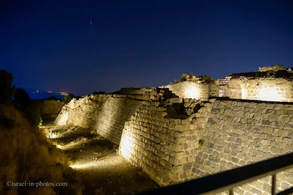
We made a short stop near the moat (point of interest #2 on the map).
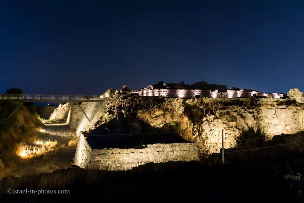
This moat is quite impressive. It is ten meters deep and twenty meters wide.
Then we continued to the observation point (point of interest #1 on the map).

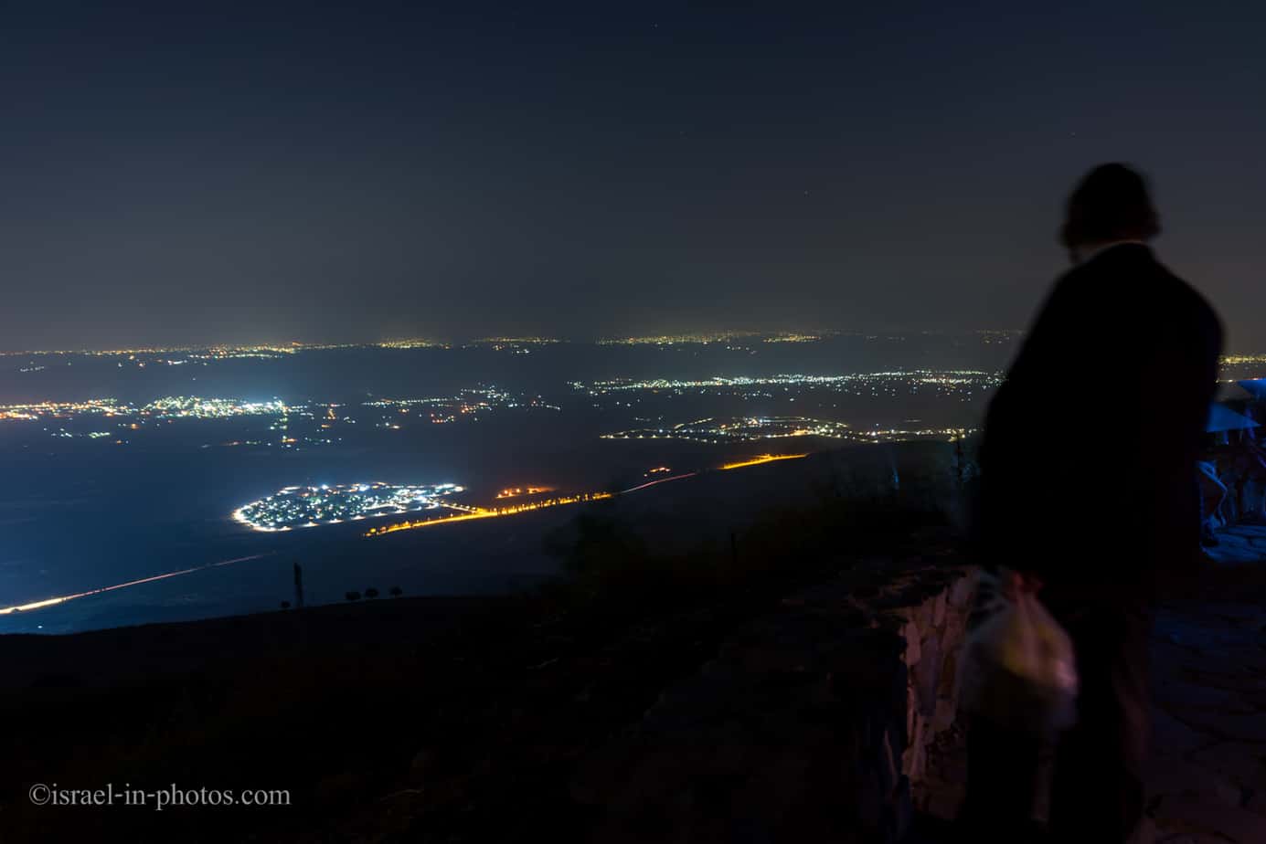
Beneath the observation point, at 220 meters below sea level, you can see the Jordan River. And the fortress overlooks three river crossings: Zinbari, Naharayim, and Beit Shean.
This site has a strategic position (see geography section). And besides commanding the crossings, it also enables the control of the road running in the valley.

Of course, you can not see the Sea of Galilee or the Jordan River at night. But you can see the lights. And the lights on the mountain in front of you come from another country, Jordan.
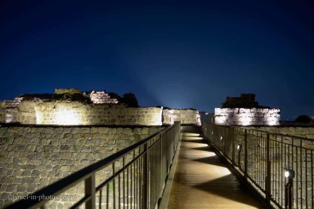
And now, let’s enter Belvoir Fortress.
Belvoir Fortress
The fortress covers about 15 dunams, and touring it gives an opportunity to obtain an impression of an almost complete fortress. The fortifications include an enormous moat and two walls – an inner wall and an outer wall. The moat was excavated out of hard basalt rock to a width of about 20 meters. and a depth of about ten meters.
The length of the outer wall surrounding the fortress is about 480 m. The postern gate in the tower of the eastern gate is remarkably well preserved. The tower camouflages it well, and it is invisible to anyone standing outside the fortress.
Most of the fortress is built of basalt stones from the surrounding countryside. Some well-tooled stones were taken from the remains of the synagogue of Hurvat HaYadid. There is a drawing of the seven-branched candelabra on one stone, and it is displayed in the Israel Museum. Unlike other buildings, the monastery church is built of carefully chiseled limestone to emphasize it and add to its beauty.

We entered the fortress through the main gate (point of interest #3 – at the bottom of the proposed layout). And probably because it was nighttime, our guide took us straight to the inner fortress.
Inner Fortress
It is a 40X40 meters stronghold, with a tower at each corner.
The keep served as an independent unit where defenders could endure a siege after the fall of the outer fortress.
View towards the inner western gate (point of interest #10 on the map):
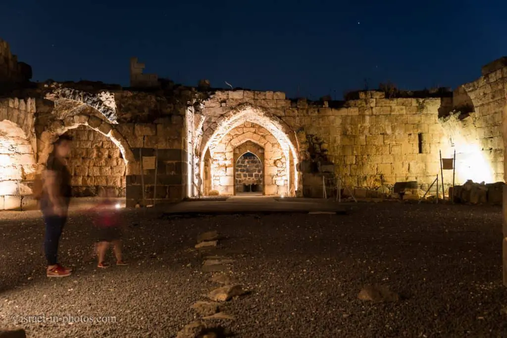
The outer courtyard and the vaults used for living quarters and storehouses are well preserved. The well in the eastern vault and the remains of the bath-house is also in good condition.
In the inner courtyard is the stronghold, which served as a fortress within a fortress. The length of the sides of this fortified square tower is 40 m. Vaults also surround the stronghold, and the halls are well preserved. In the eastern wing are the remains of the kitchen ovens. At the heart of the stronghold, there is a square stone-paved courtyard. Stairs in the western part of the courtyard lead to the second story, which is sumptuously built. Here, were a ceremonies hall, the church, and the captain’s office.

And this is the inner space when looking to the east:

Decorated stone from Kokhav synagogue
The Crusaders used the stones of the Jewish settlement to build their fortress. Here is an example of a decorated stone removed from the ancient synagogue in Kokhav.
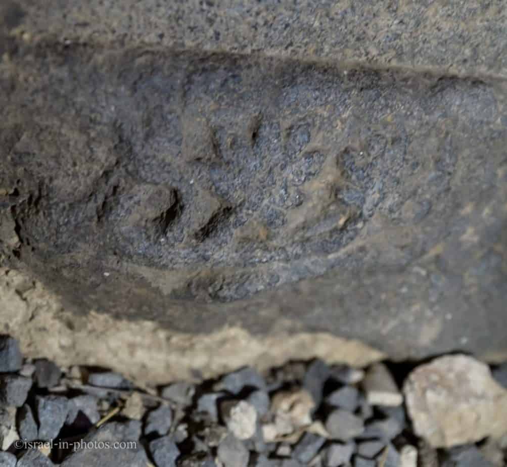
You can find the stone near the entrance to the vaults of the inner fortress (point of interest #11 on the map).

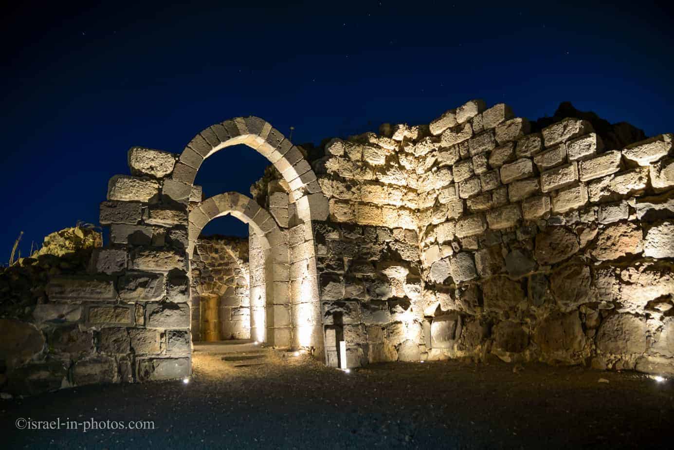
The Inner Western Gate
The inner western gate (point of interest #10 on the map) comprises two gates, a gatehouse, and a tower.

To enter this gate, you must make a ninety degrees turn inside the gate. This defense strategy was used mainly against horse riders and was quite popular. For example, you can find it at Jaffa Gate in the Old City Of Jerusalem and Crusader Gate at Caesarea National Park.
At this point, about one hour after the guided tour started, it ended. And on our way to the parking, we will pass on top of the drawbridge.
The Drawbridge
The wooden bridge that you can see today is, of course, a reconstruction.
The original drawbridge (point of interest #15 on the map) consisted of two parts. One part was made out of stone. And it was supported by a pillar standing at the center of the moat. And the second part, made out of wood, could be raised when required.
Geography
First, we need to understand why this site was initially selected. And shortly, it is a strategic point. First of all, it is the highest point in this area. And secondly, it overviews the crossing point of Jordan at Gesher and the Beit Shean to Damascus road.
Kokhav HaYarden is spread over the north-eastern edge of Ramat Kokhav, at the top of a steep slope rising 308 m. above sea level and about 550 m. above the Jordan Valley. Since lava flows filled the cracks and valleys, these heights are relatively level, leaning to the south-west, i.e., the north-eastern corner of each height is the highest point in the area. That is why the Kokhav HaYarden fortress was built in that region.
Kokhav HaYarden is strategically located. On the north-eastern boundary of the Crusader kingdom, the fortress commanded the crossing point of the Jordan at Gesher (Jisr al-Majami) and the high road from Bet Shean to Damascus. The Crusaders named the place Belvoir and Pont Jadir, based on the name of the ancient city of Gader in the mountains of Gil’ad.
Nahal Tavor, the main waterway draining the Lower Galilee, passes to the north of Ramat Kokhav. It begins at the foot of Mt. Tavor, crosses the eastern Lower Galilee, and flows into the Jordan River north of Kibbutz Neve Or. The basalt heights of the Lower Galilee formed about 4.5 million years ago, long before the Golan basalt flows.
Therefore, the rocks have had time to erode, and they are covered with a relatively deep layer of soil. The small streams flowing here attracted settlers in ancient times, and the remains of ancient settlements have been found next to almost every spring. Even today, the eastern Lower Galilee is an agricultural region, being very suited for non-irrigated crops.
History and Archeology
Here is a short extract from the official site.
Ancient Israelite Period – Kochava
The eastern edge of Ramat Kokhav appears to have been settled already in the ancient Israelite period (12th century BC). The region was within the inheritance of the tribe of Yisasskhar. Subsequently, in the Mishna and the Talmud periods (2nd and 6th centuries BC), there was a Jewish settlement named Kochava, and archaeological excavations uncovered the remains of residential homes and a public building. Some have identified this place as Grifina – a series of peaks on which, according to ancient Rabbinical sources, torches or bonfires were lit to announce the new moon.
Crusaders
The Crusaders used the stones of the Jewish settlement to build their fortress. During excavations in the fortress, carved basalt stones were found that had been taken from an ancient synagogue, among them a stone on which a seven-branched candelabra was carved. The Arabic name of the fortress, Kawkab al-Hawa (Star of the Winds), preserves the sound of the ancient Hebrew name.
In the 12 century, after the crusaders conquered the land and established the Kingdom of Jerusalem, the area of Kokhav HaYarden was included in the Principality of Galilee. Because of internal disputes, the region was handed over to the noble Velos family, who built a fortified estate there in the 30s of the 12th century.
In 1168, the Velos family sold the estate to the Knights Hospitalier, and it was they who built the strong fortress, which can be seen there to this day. The fortress was named Belvoir. Abu Shama, a 12th-century Muslim historian, described the fortress as being “set amidst the stars like an eagle’s nest and the abode of the moon.”

Muslim Period – Saladin
In the 80s of the 12th century, Saladin attacked the Crusader kingdom again and again. After the battle at Karney Hittin (1187), in which Saladin destroyed most of the Crusader army, three fortresses remained under Crusader control – Tyre, Safed, and Kokhav HaYarden. Saladin was determined to conquer Kokhav HaYarden, come what may. His forces besieged the fortress for a year and a half, and in January 1189, they succeeded in demolishing a tower on the fortress’s outer wall (the Barbican). But they discovered that the Christians were entrenched in other parts of the fortress. Both sides were already exhausted. The Crusaders agreed to hand over the fortress on the condition that they would be allowed to move to Tyre. So it was.
In 1193, after the death of Saladin, the Galilee was transferred to the control of Al-Mu’azzam ‘Isa Sharaf ad-Din, ruler of Damascus, who, due to his concern for a renewed Crusader campaign, destroyed the Kokhav HaYarden fortress. That was the condition in which the fortress was discovered in archaeological excavations, but because most of the stones were found, it was possible to restore it and present it in its full glory.
Summary
Jordan Star National Park (Kokhav HaYarden) is not a big place. And a typical visit will take one to two hours. But, despite its size, it presents an almost complete Crusader castle in Israel. And if you are driving from the Sea of Galilee to Beit Shean National Park or vice versa, consider stopping at this national park.
Have you ever been to Jordan Star National Park? Tell us about your experience in the comments below.
That’s all for today, and I’ll see you in future travels!
Stay Tuned!
Additional Resources
Here are several resources that I created to help travelers:- Trip Planner with Attractions and Itineraries is the page that will help you create your perfect travel route.
- What is the Best Time to visit Israel? To answer this question, we will consider the weather, prices, holidays, festivals, and more.
- Information and Tips for Tourists to Israel will answer the most common questions tourists have about Israel (including safety, passports, weather, currency, tipping, electricity, and much more).
- Israel National Parks and Nature Reserves include a complete list, top ten, map, tickets (Israel Pass, Matmon, combo), and campsites.
- If you are looking for things to do, here are the pages for Jerusalem, Tel Aviv, Haifa, Sea Of Galilee, Akko (Acre), Eilat, Nazareth, Safed (Tzfat), and Makhtesh Ramon.