Tel Gezer National Park – Visitors Guide – Lovely Family Trail
Tel Gezer, midway between Tel Aviv and Jerusalem, is one of the most important Biblical sites, and you can explore it using a trail.
Table of Contents
- 1 Map
- 2 Trails
- 3 Entrance Fee
- 4 Opening Hours
- 5 Restrooms
- 6 When to visit Tel Gezer?
- 7 Loop Trail at Tel Gezer
- 8 About Tel Gezer
- 9 The Gezer Calendar
- 10 Southern Lookout
- 11 Tel Gezer Water System
- 12 The Canaanite Tower
- 13 The Canaanite Gate
- 14 Solomon’s Gate
- 15 Ayalon Valley Lookout
- 16 Monolith Temple
- 17 Sheikh’s Tomb
- 18 Gezer in the Bible
- 19 Summary
Map
Tel Gezer National Park is located near roads #6 and #431 and the junction of roads #3 and #44. Its proximity to the main roads is not accidental since Tel Gezer had a strategic location – it controlled the junction of Via Maris with the road to Jerusalem.
Directions for drivers: Link to Waze and Link to Google Maps
Directions for public transport: Link to Moovit
Interactive map of the area:
Update: On our latest visit in 2024, Waze took us directly to the Tel through a dirt road. This dirt road starts about 500 meters north of Karmei Yosef on road #44. Also, while driving there, I saw a roadblock by the exit from Karmei Yosef towards the Tel. Hence, the easiest way to reach this national park is by entering its name into Waze.
Though villages and settlements surround Tel Gezer, getting to it is not always easy. Several years ago, we tried visiting Tel Gezer. I tried getting through Beit Uziel that time, but all roads to the Tel were blocked. We finally reached the Tel but had to make a long hike.
In 2022, we drove to Gefen Street in Karmei Yosef and started our hike there. However, when I checked the official site, I saw that starting in March 2022, Karmei Yosef decided to block the road to Tel Gezer.
Trails
Here is an interactive map from israelhiking.osm.org.il where the most popular trail is marked:
| Name | Color of the Trail on the Map above | Description | Distance (km) | Total climb and descent (meters) | Notes |
|---|---|---|---|---|---|
| Short loop trail | Blue | It begins at Tel Gezer parking and goes through all points of interest at the hilltop. | 1.4 | 32 | It is the most popular variation of this trail. |
| Short loop trail + Ein Vered Spring | It is the same as the previous track with an additional visit to Ein Vered. | 3.6 | 256 | At Ein Vered Spring, there is a small pool (1.5 meters in depth) filled with water from the end of winter till the beginning of summer. |
Entrance Fee
Free.
Opening Hours
Always open. But it is prohibited to visit at night.
Restrooms
None.
When to visit Tel Gezer?
There are few trees and almost no shade along the path, so summer is the worst time to visit. Also, this is a popular trail, and many people visit it. Hence, the later you arrive, the further you must park.
Note: the word Tel is mentioned many times during this article. You can check the meaning at What Does Tel Mean?
Loop Trail at Tel Gezer
Let’s take the short loop trail. Our hike began at Gefen Street in Karmei Yosef (see directions in the map section above).


Note: The parking lot at the top of the Tel is small. But in 2024, we saw that a new parking was constructed along the road.
About Tel Gezer
At the top of the Tel, you can find explanatory signs like this:

Note: lighting fire at Tel Gezer National Park is prohibited.
Tel Gezer is one of the most important biblical sites in Israel. It contains impressive remains, among them the city walls, a huge tower, and a monolith temple, all from the Canaanite period. “Solomon’s Gate” was also discovered, as well as the Gezer Calendar (the most ancient Hebrew inscription ever found), dated to the Israelite period.
Tel Gezer extends over 130 dunams and contains 26 levels of settlement, from the Chalcolithic to the early Roman periods (3500 BCE to 100 CE).
Most of the remains date from the Middle and Late Canaanite and the Israelite periods. During these times, Gezer was an important city controlling the junction of the Via Maris with the road to Jerusalem.
The city of Gezer was known from several sources. However, the first scholar to identify it was Clermont Ganneau in 1871. From 1902 to 1909, Macalister excavated it for the Palestine Exploration Fund. From 1964 to 1973, excavations were conducted by Wright, Dever, and Seger for the Hebrew Union College Biblical and Archaeological School.
Source: signs

The Gezer Calendar
The Gezer Calendar is a 10th-century BCE inscription on a small limestone tablet. Here is an enlarged replica:
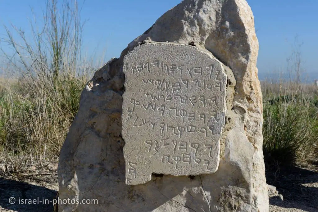
The Gezer Calendar, which measures 7 x 11 cm, is considered the oldest ancient Hebrew document so far discovered. It was found by Macalister among mounds of excavated material from his dig. It is now on display at the Istanbul Archaeological Museum. The calendar is generally believed to be a record of agricultural work done during the 12 months of the year.
Translation of the inscription:
Two months of harvest
Two months of sowing
Two months of late planting
One month of hoeing flax
One month of barley harvest
One month of harvest and measuring
Two months of vine pruning
One month of summer [fruit]
Source: sign

Southern Lookout
Tel Aviv and the surrounding cities can be seen from the southern observation point.

You can also see the entrance to the water system (to the left in the following photo) and the Canaanite tower (to the right of the following image).

Around Tel Gezer, 12 rocks with an inscription “Boundary of Gezer” in Hebrew and a Greek word that means “to Alkios” were found. The inscription dates from the Hasmonean period and probably marked the city limits at that time. The location of five inscriptions can be seen in the panorama photograph.
Source: sign

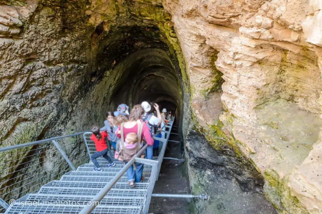
Tel Gezer Water System
From the lookout, we continued down towards the water system.

In December 2021, the water system at Tel Gezer was opened. It was used a long time ago (3,600 years). And its depth is 60 meters.

The stairs to the water system are not very wide, so they are not recommended if you are claustrophobic. There are 175 stairs, so wear appropriate shoes and take flashlights.
Here is a diagram of the water system:

You are now in Gezer’s ancient water system. The residents of the city dug it to reach groundwater, which is about 40 meters below the surface. So far, you have been going through the open part of the system. From this point, a 40-meter-long tunnel slopes downward; at the bottom is a cave and a basin to collect the water (from the water table). The residents of the city would go down the water shaft to draw water from the basin in times of peace as well as war. A large portion of the tunnel is now stopped due to numerous cave-ins since Macalister first excavated it in the early 1900s. Excavations are now being conducted to fully explore the water tunnel and cavern basin.
Source: sign
And at the bottom, you can find water even today (3,600 years later).


If you look under the stairs, you can see the remains of the old stairs.

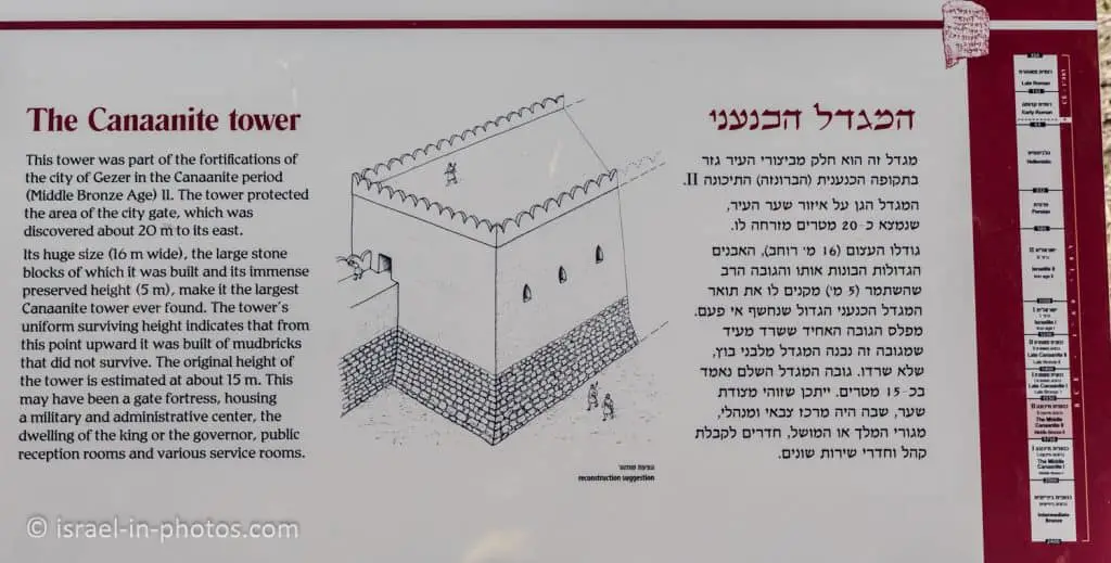
The Canaanite Tower
You can find the Canaanite tower near the water system entrance.

This tower was part of the fortifications of the city of Gezer in the Canaanite period (Middle Bronze Age) 2. The tower protected the area of the city gate, which was discovered about 20 meters to its east.
Its huge size (16 meters wide), the large stone blocks of which it was built, and its immense preserved height (5 meters) make it the largest Canaanite tower ever found. The tower’s uniform surviving height indicates that from this point upward, it was built of mudbricks that did not survive. The original height of the tower is estimated at about 15 meters. This may have been a gate fortress, housing a military and administrative center, the dwelling of the king or the governor, public reception rooms, and various service rooms.
Source: sign
The Canaanite Gate
The gate and the tower were part of a wall that surrounded the city. The gate is typical of this period; it is constructed of mud-brick on a stone foundation and is preserved to a height of seven meters. Huge stone pilasters protruding into the passageway narrow its width. On the outside were wooden doors that did not survive. From the gate, the city wall continues left and connects to the remains of the gigantic watchtower. The tower was about 16 meters wide and more than 20 meters long! It is the largest fortification of its type in Israel.
Source: sign


We continue along the trail for about five minutes till we reach Solomon’s Gate.
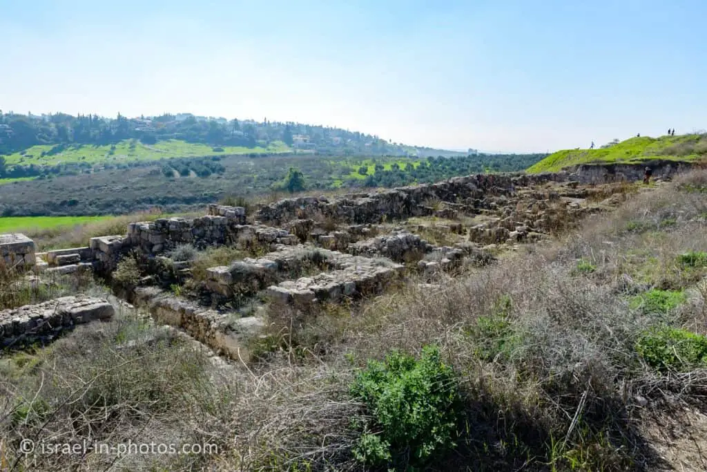
Solomon’s Gate
In this area, You can see the remains of the Israelite city.

Here is a panorama of the area with Solomon’s Gate in the middle:


The gate consists of three rooms on either side of a passageway. A stone bench lined the walls in each of them. In the room to the far left a large stone basin was found. The floor of the passageway had a rainwater drainage channel covered with paving stones. On both sides of the gate’s outer opening, towers were incorporated into the city wall. The gate, very similar to those discovered at Hazor and Megiddo, was probably built in the 10th century BCE. It shows evidence of a major fire, which can apparently be attributed to the violent conquest by Pharaoh Shishak in 925 BCE.
The connection between Hazor, Megiddo, and Gezer is also reflected in the following verse that describes Solomon’s building activities: “This was the purpose of the forced labor which Solomon imposed: It was to build the House of the Lord, his own palace, the Millo, and the wall of Jerusalem, and [to fortify] Hazor. Megiddo, and Gezer” (Kings 9:15).
Source: sign
For additional information about the other places, see Tel Megiddo National Park and Tel Hazor National Park.
We will continue following the trail till we reach Ayalon Valley Lookout.
Ayalon Valley Lookout
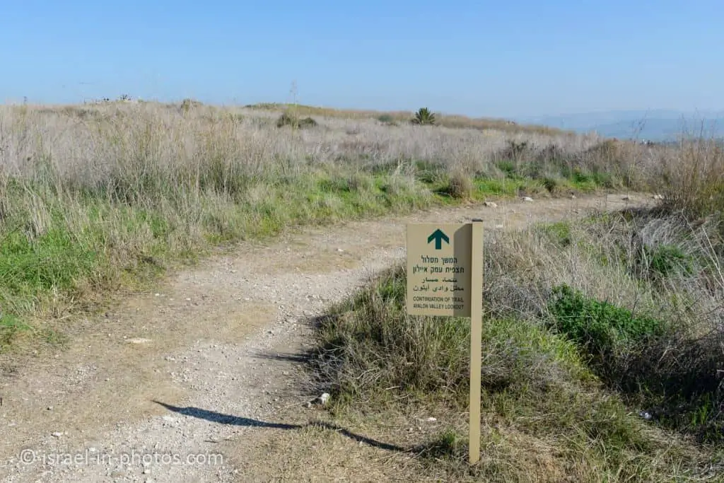
And here are several panoramas from Ayalon Valley Lookout.


Our next point of interest was the shrine area.
Monolith Temple

Scholars believe the temple served as a venue where alliances between tribes or city-states were forged or renewed. The 10 monoliths may have symbolized the city of Gezer and nine allied cities in its vicinity. The basin may have served as a container for a blood libation poured during an alliance ceremony. A ritual of this type is described in the Bible after Moses brought the Ten Commandments down. Mount Sinai:
“Moses then wrote down all the commands of the Lord. Early in the morning he set up an altar at the foot of the mountain with twelve pillars for the twelve tribes of Israel Moses took one part of the blood and put it in the basins, and the other part of the blood he dashed against the altar” (Exodus 24:4-6).
Source: sign


The last archeological finding is a more recent one.
Sheikh’s Tomb
This structure is a remnant of a sheikh’s tomb, apparently built before the year 1600. It is believed to be the tomb of Sheikh Mohammed al-Jazarli, in whose name the ancient word Gezer is preserved. This tomb was sacred to the inhabitants of Abu-Shusha, a small village that was located on the southwestern side of the tell.
Source: sign


After an additional 200 meters, you will reach the parking lot. And the path ends.
Gezer in the Bible
Gezer is mentioned in various historical sources.
And here are several of the Biblical mentions:
Joshua 10:33 (New International Version)
Then King Horam of Gezer came up to help Lachish, and Joshua struck him and his people, leaving him no survivors.
Note: Lachish is also a stunning place. And you can find additional details at Tel Lachish National Park.
1 Kings 9:15 (New International Version)
Here is the account of the forced labor King Solomon conscripted to build the Lord’s temple, his own palace, the terraces, the wall of Jerusalem, and Hazor, Megiddo and Gezer.

Summary
The short loop trail took us about two hours at a slow pace (with small children). It is a lovely short trail, with many points of interest, close to the center, and the path is suitable for families. Thus, it is a popular place, and I suggest arriving early during the weekends and holidays.
This area has many attractions. You can explore them using the interactive map above.
Have you visited Tel Gezer? Tell us about your experience in the comments section below.
That’s all for today, and I’ll see you in future travels!
Stay Tuned!
Additional Resources
Here are several resources that I created to help travelers:- Trip Planner with Attractions and Itineraries is the page that will help you create your perfect travel route.
- What is the Best Time to visit Israel? To answer this question, we will consider the weather, prices, holidays, festivals, and more.
- Information and Tips for Tourists to Israel will answer the most common questions tourists have about Israel (including safety, passports, weather, currency, tipping, electricity, and much more).
- Israel National Parks and Nature Reserves include a complete list, top ten, map, tickets (Israel Pass, Matmon, combo), and campsites.
- If you are looking for things to do, here are the pages for Jerusalem, Tel Aviv, Haifa, Sea Of Galilee, Akko (Acre), Eilat, Nazareth, Safed (Tzfat), and Makhtesh Ramon.