

Snir Stream Nature Reserve (Hasbani) – Visitors Guide

Snir Stream Nature Reserve (Hasbani) in Upper Galilee offers various nature hikes, including water trails. Thus, it is the perfect place for hot summer days.
Map
Snir Stream Nature Reserve (Hasbani) is located in Upper Galilee near Kibbutz Dafna. If you are familiar with Dag Al Dan restaurant, the entrance to this nature reserve is very close to the restaurant. And the easiest way to reach this spot is by entering its name into Waze.
Directions for drivers: Link to Waze and Link to Google Maps
Directions for public transport: Link to Moovit
Interactive map of the area:
And here is its map:

Closeup map:
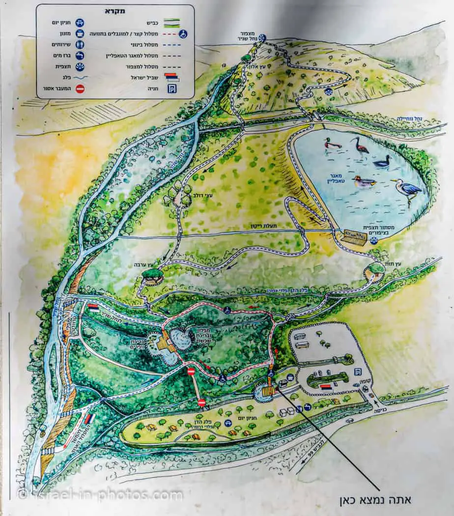
Note: you can click on the map to enlarge it.
Trails
On the first map, you can see the long trail. On the second map, you can see several shorter paths. Here is an interactive map from israelhiking.osm.org.il where these trails are marked:
And here are the details of the tracks:
| Name | Color of the Trail on the Map above | Color of the Trail in the Official Booklet | Description | Distance (km) | Total climb and descent (meters) | Average duration (minutes) | Notes |
|---|---|---|---|---|---|---|---|
| Accessible loop trail – short trail | Red | The trail leads from the parking lot to the wading pool and back. | 0.7 | 20 | 15 | ||
| Medium trail | Blue | Light Blue | See the age recommendation in the medium path. | 1 | 34 | 30 | According to the official booklet: “not recommended for children under five.” |
| To the TAP Line Reservoir | Black | Dark Blue | This trail leads to the bird hideout by the Tapline reservoir | 0.8 | 26 | 20 | I marked the trail and started the measurement from the first junction. |
| Snir Stream Lookout | Brown | Green | Extends the previous trail till Snir Stream lookout | 2.3 | 98 | 40 | I marked the trail and started the measurement from the first junction. |
| The long trail | Orange | Orange | Extended version of the medium path. | 2.7 | 88 | 90 | See age recommendation in the medium path. |
Note: the listed average durations are according to the official brochure. During our latest visit, we hiked the medium trail. And instead of the mentioned half an hour, it took us about two hours. That is because we made long breaks by the water (and most people do them).
All trails begin at the parking by the Snir Stream Nature Reserve (Hasbani) entrance, all of which are loop trails.

Opening Hours
Sunday – Thursday and Saturday: 8:00 – 17:00 (16:00 in winter).
Friday: 8:00 – 16:00 (15:00 in winter).
On holiday eves, usually 8:00 – 13:00.
Note: Since the pandemic, the Israel Nature and Parks Authority has started limiting the number of people in each park. Thus, reservations are recommended through the official site (you can find the link below).
Entrance Fee
Adult – 28 NIS, child – 14 NIS, and student – 24 NIS. Free for National Parks annual subscribers.
If you visit several National Parks, consider purchasing a combo ticket. For additional information, see National Parks and Nature Reserves.
Note: opening hours and ticket prices were updated in February 2023. In any case, recheck the official site before visiting.
Dogs
It is forbidden to enter Snir Stream Nature Reserve with dogs.
Picnic and Barbeque
You can find a picnic area, restrooms, and a kiosk near the parking lot.

According to the sign, the picnic area closes at 17:00 (16:00 in winter). Also, fires (barbecues or campfires) are prohibited throughout the reserve.


Contact Information
Phone: 04-6950064
Hasbani River or Snir Stream
This river flows in two countries. The Hasbani runs for 40 km in Lebanon before crossing the border at Ghajar. And then, Snir Stream joins Banias and Dan Rivers to form the Jordan River.
Hasbani is the name of this river in Arabic and is still called this way in Lebanon. And it is called after Hasbaiyya town in Lebanon, located near the stream. Snir is the Hebrew name.

What does Snir mean?
Snir Stream is named after Snir Mountain, which is one of the Biblical names of Mount Hermon.
Deuteronomy 3:9:
Hermon is called Sirion by the Sidonians; the Amorites call it Senir.
The Blue Loop Trail
If you plan on making one of the water hikes, wear water shoes. The wet trail has plenty of big rocks. Thus water shoes with sturdy soles would be the best alternative.

There are clear trail markings in this nature reserve. Thus, we did not use a map for the blue trail.

Note: flooding is a hazard at Snir Stream Nature Reserve (except in summer). Therefore, I would advise calling this nature reserve before visiting in the rainy season.

Since we visited during the summer vacation with the kids, we preferred the trail with lots of water. Hence we chose the blue trail, which goes through the wading pool and travertine falls.


We continued along the red tail, and after five minutes, we reached the wading pool.
Wading Pool
The wading pool is not deep (40 cm), but the water was freezing even in August.


Man-made pools – between the parking area and the river itself, two pools have been excavated. One is a “wading pool” for visitors’ pleasure, while the second is a refuge for rare water plants, such as the yellow pond-lily (Nuphar lutea) or the dwarf water clover (Marsilea minuta), which are almost extinct in the wild in Israel.
Note: unless stated otherwise, all quotes were taken from the