Nahal HaShofet – Accessible Trail for Families by Yokneam
Nahal HaShofet offers various trails, including an easy loop and an accessible path with pools and breathtaking nature.
Note: Nahal HaShofet reopened after renovations in April 2024. We revisited it in September 2024, and most of the photos and the video are from that visit.
Table of Contents
Map
Nahal HaShofet is located near Menashe Heights, not far from Yokneam.
When driving on road #66 from Yokneam towards Megiddo after Hazorea, you will see a turn right towards “Ramat Menashe Park” and “Nahal HaShofet.” Follow the signs, and you will reach Nahal HaShofet.
Alternatively, search for Haruvim Parking at Nahal HaShofet on Waze or click one of the links below.
Directions for drivers: Link to Waze and Link to Google Maps
Directions for public transport: Link to Moovit
Interactive map of the area:
Notes:
- See the map of the accessible trail below.
- While in the forest, you may lose cellular reception. However, plenty of signs point to the beginning of this trail.
Tracks
Nahal HaShofet has a variety of trails. And KKL-JNF created a loop wheelchair-accessible track. This path goes through many attractions, and because it is accessible, it became popular among families with small children (you can hike with a baby stroller).

Note: you can click on the map to enlarge it.
Here is an interactive map from israelhiking.osm.org.il where the most popular trails are marked:
Notes:
- As you can see, the longer trails include the short path (wheelchair-accessible trail).
- The color I used to mark the trails is not the actual color on site.
- All the marked trails start and end at Haruvim Parking.
Here are the details of those trails:
| # | Name | Color of the Track on the Map above | Description | Distance (km) | Total climb and descent (meters) | Notes |
|---|---|---|---|---|---|---|
| 1 | The short path – wheelchair-accessible trail | Blue | The loop trail takes you through different points of interest. | 1.6 | 78 | It is by far the most popular option. |
| 2 | Longer track #1 | Red | Short path + En Parur, Tel Parur (optional) + flowers (on season) | 5.5 | 190 | |
| 3 | Longer trail #2 | Green | Short path + flowers (in season) | 5.2 | 155 |
Cycling Trails
The trail contains about 30 kilometers of riding in the unique landscape of the Biosphere region “Ramat Menashe” within the Megiddo Regional Council. Most of it crosses the KKL-JNF Forest following remarkable landscape and sceneries. The trail includes about 22 km of “single-tracks”, and the rest are forest roads. The trail is built of two rings that meet in a mid-point, allows switching between them. The trail is designed as a one-way direction and suited for mid-range class riders.
Source: sign

Blue ring: 17,100 meters, and ascent height is 370 meters.
Yellow ring: 12,760 meters, and ascent height is 212 meters.
Opening Hours
Always open.
Entrance Fee
Free.
Contact Information
KKL-JNF’s Forest Hotline: 1-800-350-550
When to visit?
Nahal HaShofet has water all year round (though in Autumn, there will be little water). Thus, you can visit anytime. But if you want to enjoy cooler weather and see flowers, I suggest visiting towards the end of Winter and during the Spring.
If you plan to visit on a Saturday or during the holidays, remember that it is a popular place. Therefore, arrive early or visit during weekdays.
The Accessible Route at Nahal HaShofet
Here is an accessible circular hiking route, which is one point six km long.
The path descends along Nahal Sanin and Nahal Hashofet to the flour mill and the cave of camels, goes up to Ein Hashrat and returns here in the shade of a forest of pine trees. On the way, you will meet rich riverside vegetation, a waterfall, a spring that springs from the rock, and impressive ancient remnants.
In winter, the stream flows strongly. Towards the end of summer, the flow of water gradually weakens, but the stream stays beautiful as always.
In two sections the slope of the path is greater than the accessibility standard:
1. Up the flour mill to Ein Hashrat – about 120 meters.
2. From Ein Hashrat towards the parking lot – about 300 meters. Cumulative height difference – 31 meters.
Source: sign
Now, I will take you through the most popular path. It is an almost two-kilometer accessible trail suitable for baby carriages.

At the beginning of the trail, you will see explanatory signs and restrooms.


Nahal Sanin Pools
After walking for several minutes, you will reach Nahal Sanin Pools. This new pool was constructed during the last renovation. It aims to prevent flooding and protect the stream’s banks from erosion.
The pool is relatively small and shallow (its depth in August was about 10-20 cm). And you will probably see kids in the water.

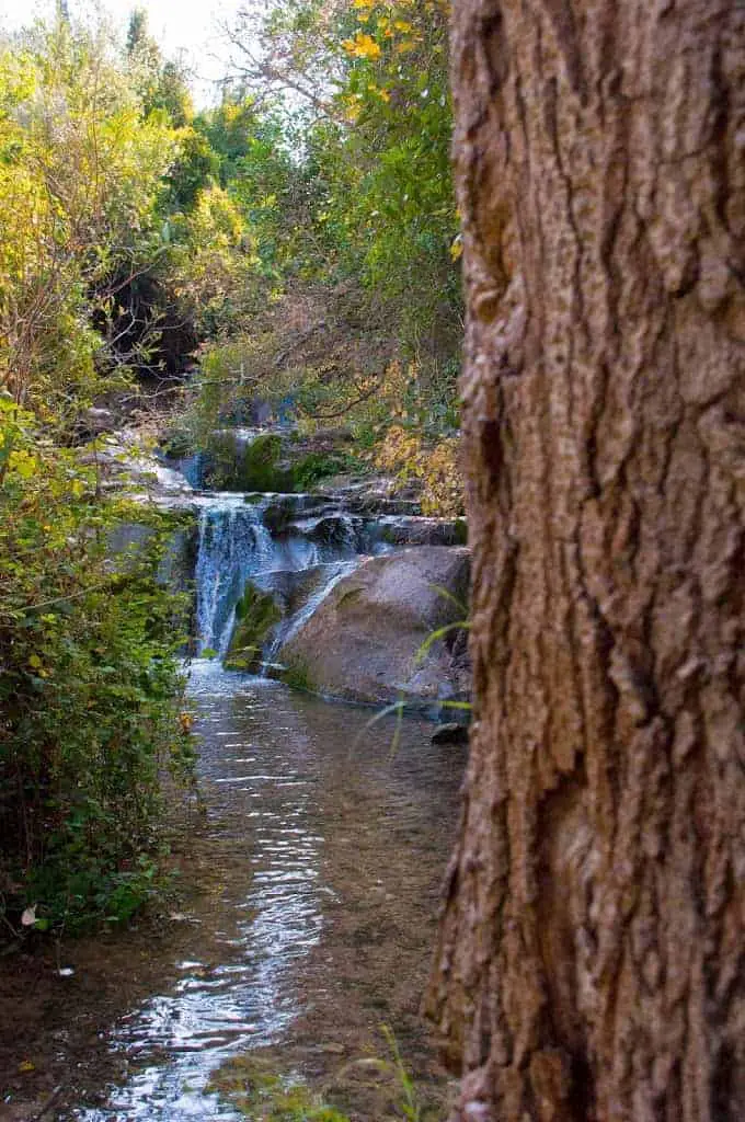
Nahal HaShofet Waterfall
The path descends at first along Nahal Sanin, a short tributary of Nahal HaShofet in which water flows until the end of summer. Dense foliage adorns the river banks.
Further on, Nahal Sanin meets up with Nahal HaShofet, and the path continues along the bank. The flowing stream creates a small waterfall and a pool. A nearby lookout platform provides a view of this beautiful spot, which is dotted with field elms (Ulmus minor), a tree that grows only beside the water and which is rarely found in Israel. In the winter the elm sheds the asymmetric serrated leaves that make it easily identifiable for the rest of the year.
Source: KKL
The easiest way to reach the pools by the waterfall is to go to the lookout platform. At its end, you will see new stairs. After about five stairs, you will be by the lower pool. Similar to the previous pool, it is shallow and not big.


The Dam – Hydrometric Station
The Water Authority places hydrometric stations that permanently measure and record the amount of water in Israel’s streams. Particularly intense rainstorms sometimes caused flooding and damage in Kibbutz HaZorea.
In a rainy year, water flows in Nahal HaShofet in an amount that can supply the residents of Yokneam for an entire year!
The station is named after Paul Gilad, who was the director of hydrometry in the water authority’s northern district.
Source: sign


As you can see, though significant parts of the trail are shaded, not all of it is. Thus, in any case, take sunscreen.
Carved Caves
Hundreds of caves, all man-made, have been carved around Nahal HaShofet, especially in the adjacent Tel Kira.
Many of the caves were used as tombs and quarries for building materials, and later, they were utilized for various purposes – works, hops, warehouses, and animal shelters.
Source: sign


The Camel’s Cave
On the way to the Camel’s cave, you will see another small pool – Historic Water Canal.


You will then see two bridges. Cross to the other side of the stream and continue for about twenty meters to the cave.


Like other caves in Ramat Menashe, this large cave was carved by human hands. We don’t know when the cave was dug or for what purpose. The black color on its sides indicates many nights of smoke from fires.
According to the mythology of Kibbutz Hazorea, camels were housed in a cave and helped remove trunks cut down after a forest fire.
Source: sign
If you choose trail #3, you continue with the trail toward Hazorea.
Note: There are many lovely spots along the way and several rest areas with benches. Hence, you will see many people having picnics along the trail.
Cross back using one of the bridges, and you will reach the flour mill within several minutes.
Flour Mill
This Ottoman-era flour mill was operated by water. And here is a sign with additional explanations.


A short walk uphill will lead you to the next point of interest.
Ein Hashrat (Ein Ami)
The spring flows from a narrow tunnel whose front is shaped like an arch.
It is possible that under the arch, they placed a statue of a god in whose honor a type of religious worship was held. The spring’s water was collected into carved pools.
The name “Hashrat” is derived from the Arabic name of the place – Ein al-Mahshura, which means a spring that flows from a narrow place.
Kibbutz HaZorea dedicated the spring in memory of Ami Bar-Ner (1950-1970), a member of the kibbutz, who fell during his military service.
Source: sign


Near Ein Hashrat (Ein Ami), you will see a sign. If you turn left, then you return to the parking. And if you turn right, then after 750 meters, you will reach Wilfrid Israel Museum. Here is a quote from the official site:
The Wilfrid Israel Museum of Asian Art and Studies began life with a collection of Near and Far Eastern art bequeathed to the kibbutz by Wilfrid Israel (1899-1943), friend and patron of its young founders. Israel was the last heir of a Berlin Jewish business dynasty and an ardent pacifist in his youth. He became one of the leading figures in the rescue of Jewish children and youngsters from Nazi persecution before and during the Second World War.
If you want to visit the museum, check its opening hours.
We will turn left and return to the parking.


How Much Time Does the Short Path Take?
Completing the accessible route at Nahal HaShofet can take 40 minutes (without long stops) to several hours (if you have a picnic and stop at the pools). Usually, it takes us 1-2 hours.
About Nahal HaShofet
Nahal HaShofet is a short river that rises between Moshav Ein HaEmek and Kibbutz Ramat HaShofet. This is the site of the river’s most important spring, Ein Rehaniya.
The river flows through a landscape of rounded hills and crosses Kibbutz HaZorea before entering the open spaces of the Jezreel Valley, where it becomes a canal that empties into the Kishon River. The river flows through Ramat Menashe for about seven kilometers, and through the Jezreel Valley for about another three kilometers. Nahal HaShofet’s catchment basin is soon to be declared a core heritage site in the Ramat Menashe Biosphere Reserve.
Source: KKL
Summary
Nahal HaShofet has a lovely short route. Families with children love this trail since kids can play in the water, explore caves, and enjoy nature. Moreover, if you have a baby, you can use a stroller.
Have you ever been to Nahal HaShofet? Tell us about your experience in the comments below.
That’s all for today, and I’ll see you in future travels!
Stay Tuned!
Additional Resources
Here are several resources that I created to help travelers:- Trip Planner with Attractions and Itineraries is the page that will help you create your perfect travel route.
- What is the Best Time to visit Israel? To answer this question, we will consider the weather, prices, holidays, festivals, and more.
- Information and Tips for Tourists to Israel will answer the most common questions tourists have about Israel (including safety, passports, weather, currency, tipping, electricity, and much more).
- Israel National Parks and Nature Reserves include a complete list, top ten, map, tickets (Israel Pass, Matmon, combo), and campsites.
- If you are looking for things to do, here are the pages for Jerusalem, Tel Aviv, Haifa, Sea Of Galilee, Akko (Acre), Eilat, Nazareth, Safed (Tzfat), and Makhtesh Ramon.